


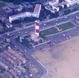

Chennai lighthouse (E India)
4.1nm
201°
The currents N of Chennai ...
26 Mar 12
Jojo
| Latitude | Longitude | |
| DMS | --- | --- |
| DM | --- | --- |
| DD | --- | --- |

 channel 10, 16
 port (E India)")
 port (E India)")
 Chennai Port, formerly known as Madras Port, is the second largest port of India, behind the Mumbai Port, and the largest port in the Bay of Bengal and the principal harbor of Coromandel coast.
It is an artificial and all-weather port with wet docks that front s the center of the city. It was a major travel port before becoming a major container port.
Chennai Port, formerly known as Madras Port, is the second largest port of India, behind the Mumbai Port, and the largest port in the Bay of Bengal and the principal harbor of Coromandel coast.
It is an artificial and all-weather port with wet docks that front s the center of the city. It was a major travel port before becoming a major container port.Cyclones at Chennai usually commence with the wind between NNW and NNE, the wind direction changing to the E or W according to whether the port is in the right-hand or left-hand semicircle of the storm. The Chennai coast is normally frequented by cyclones during May, October, and November.
Rainfall is almost entirely confined to the period from No Winds—Weather.—Cyclones at Chennai usually commence with the wind between NNW and NNE, the wind direction changing to the E or W according to whether the port is in the right-hand or left-hand semicircle of the storm. The Chennai coast is normally frequented by cyclones during May, October, and November.
Rainfall is almost entirely confined to the period from November to January during the Northeast Monsoon. In April and May, there are occasional squalls from the NW, usually in the early part of the night.
Weather reports are broadcast by the radio station at Chennai.
The climate of Chennai is considered quite hot. Even in the cooler months of December and January, the mean temperature is about 25°C.
The tides at Chennai are semidiurnal and subject to a diurnal inequality which may advance or retard the times of HW and LW; this inequality may increase or diminish the rise by as much as 0.3m.
The approach channel, marked by the IALA Maritime Buoyage System (Region A), is dredged and maintained at a depth of 19.2m. Vessels are to keep at least 0.5 mile off the channel entry unless a pilot is on board.
The harbor entrance is maintained to a depth of 18.6m, and there is a swinging basin, 0.3 mile in diameter, lying immediately inside the harbor entrance with a maintained depth of 18m. In 1986, it was reported the port could accommodate vesels up to 274m length, with a draft of 16.2m.
Bharathi Dock, the N part of the harbor, is protected by the North Breakwater and East Breakwater; a light stands near the head of East Breakwater. Dock 1 and Dock 3, on the E side of Barathi Dock, are oil berths. Dock 2, located in the NW corner of the dock, is an iron ore berth.
A fully mechanized container terminal, with alongside charted depths of 11.5 to 12.5m, is located on the W side of Bharathi Dock close NW of North Pier.
The S part of the harbor, forming the Inner Harbor is protected by East Quay. The entrance lies between North Pier and a spur projecting from East Quay; it is 122m wide with a depth of 9.4m and marked by lighted beacons at each side of the entrance.
The protecting breakwater N of the spur is known as the sheltering arm; a light stands at the head of the arm. Dr. Ambedkar Dock (Inner Harbor) contains 12 berths alongside the quays and one fixed mooring.
It has been reported (2006) that the alongside depths are being increased to 15m.
Jawahar Dock, entered along the mid-section of South Quay of the inner harbor, has an overall length of 655m. The S end of the dock is used by LASH barges. It has been reported (2006) that the depth in the dock has been increased to 11.5m.
Chennai Fishing Harbor is located 1 mile N of Bharathi Dock and is sheltered by two extensive breakwaters which provides berths for up to 500 fishing vessels.
Depths off the harbor shoal gradually from the 20m curve, about 1.5 to 2 miles offshore, to a depth of 11m less than 0.3 mile E of the breakwaters.
The surf N and S of the harbor generally breaks about 122m from the beach in fine weather and about 183m in squally weather. During gales from the E, breakers were observed about 244m offshore; with an offshore wind, the surf is often very high and in the form of a heavy roller. During normal weather the surf wave is about 0.9 to 1.8m high, and during a gale from 3 to 3.7m high.
Pilotage is compulsory for vessels over 200 grt.
The Port Signal Station is located on the Harbor Office on the seaward end of the Transit Shed and Passenger Terminal on North Pier. International Code of Signals Flags and Morse code are employed.
The port can be contacted, as follows:
1. Call sign: Port Control
2. VHF channels 10 and 16
3. Tel: 91-44-25360833
4. Fax: 91-44-25384012
5. Mail: dc@chennaiport.gov.in
Chennai Roadstead is open to all except offshore winds. There is usually a swell from seaward which causes vessels to labor or roll considerably.
Vessels which are not awaiting berth on arrival are not to anchor N of latitude 13°06'N, and within Pilot Boarding Area No. 1 or Pilot Boarding Area No. 2, without prior approval from Port Control.
A dangerous wreck, with masts exposed, lies about 0.8 mile SE of the harbor entrance. It is marked by a lighted buoy lying 0.2 mile E.
An Examination Anchorage area is shown on the chart.
Caution.—Vessels are advised to be on the lookout for pirates attempting to board at night.
The roadstead fronting the harbor area is subject to a heavy surf.
Ebook | Bay of Bengal
|


