
| Latitude | Longitude | |
| DMS | --- | --- |
| DM | --- | --- |
| DD | --- | --- |
 channel 12, 16
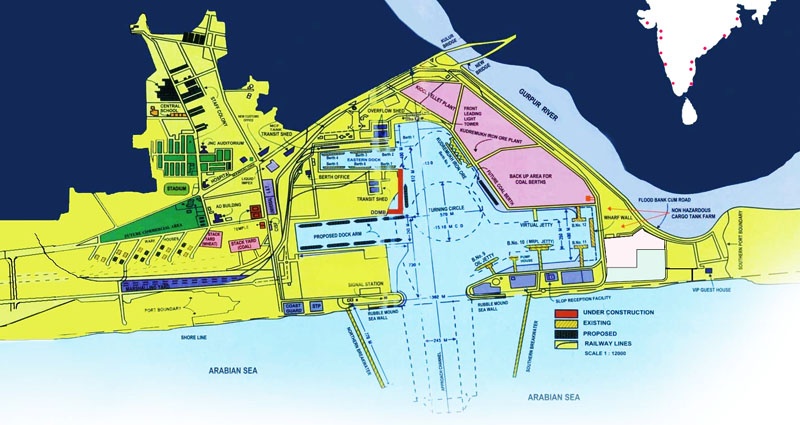
 The port of New Mangalore, a major all-weather port, is situated about 5 miles NNW of the old Mangalore port.
Fairway Lighted Buoy is moored about 4 miles W of the port. Range lights, in line bearing about 079°, at the E side of the port, mark the approach channel through the entrance.
A signal station and port radio station are situated on the N entrance point of the port. A white concrete tower lies close S of the S entrance point. Two towers, one of which is conspicuous, lie a short distance inland from the head of the harbor.
There is a conspicuous water tower about 0.2 mile S of the S entrance point of the harbor.
The berths are used for general cargo, the export of iron and manganese ore, and the import of materials for a chemical and fertilizer factory.
The port is approached by a channel about 4 miles long and 245m wide; it is maintained by dredging to 15.4m and marked by lighted buoys.
Several shoal patches, depths of 7.5 to 9.7m, lie close S of the channel and are best seen on the chart.
A depth of 15.1m is maintained within the harbor leading from the entrance to the turning basin. It has been reported that the maximum depths allowable for entry into the harbor can be reduced during the Southwest Monsoon (May-September) period so vessels drawing 14m or more should check with the Port Authority for the latest information.
Pilotage is compulsory for vessels over 200 grt and is available 24 hours for vessels up to 245m in length. Vessels whose loa exceeds 245m, including Suezmax tankers, are handled only during daylight hours.
Pilots board, as follows:
1. Vessels with a maximum draft up to 10m—About 1 mile ENE of Fairway Lighted Buoy (12°55'13.8''N, 74°45'33.0''E.).
2. Deep-draft vessels—Close NW of Fairway Lighted Buoy (12°54'57.0''N, 74°44'16.8''E.).
The pilots can be contacted, as follows:
1. VHF: VHF channels 12 and 16
2. Telephone: 91-824-2407428
91-824-2407341
Vessels should send an ETA message at least 48 hours in advance. The message should contain the following information:
1. Vessel name.
2. Nationality.
3. Call sign.
4. Draft fore and aft.
5. Length overall.
6. Gross tons and nrt.
7. Last port of call.
An ETD message should be sent to the harbormaster’s office at least 2 hours in advance.
A Vessel Traffic Management System is in operation in the port. Vessels will be automatically identified as they enter the port (about 4 miles from the inner harbor) so there will be no need for communications between the vessel and Port Control.
Storm signals are displayed from the signal station; the General System is used.
Tel: 91-824-2407428
91-824-2407300
Fax: 91-824-2408390
91-824-2408300
Mail: nmptdc@sancharnet.in
Anchorage is recommended NNW of Fairway Lighted Buoy, in depths of 16 to 18m. A spoil ground is established about 1 mile S of Fairway Lighted Buoy.
Caution.—Stay well clear of a dangerous wreck lying close S of the anchorage. Haze settles over the land after sunrise.
Even during good weather, the coast remains indistinct until about the middle of the day, making normally conspicuous objects difficult to discern.
Mangalore Harbor lies in the backwater formed by the confluence of the Gurpur River and the Netravati River. The port is only of importance to coastal vessels, as it is fronted by a shallow bar between low sandy spits. The port is closed from June through August during the Southwest Monsoon, when the bar is impassable. A shoal, with a depth of 15m, lies 6.5 miles WNW of the entrance to Mangalore.
The town of Mangalore is almost entirely concealed from the offing, but the following landmarks are conspicuous:
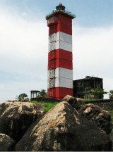
1. Mangalore Light, a squat, white, masonry tower with black bands, attached to a house resembling a small chapel, about 0.5 mile ENE of the harbor entrance.
2. A 41m high dome, surmounted by the steeple of the Roman Catholic Cathedral, about 0.5 mile N of the light structure.
3. The 76m high square tower of Saint Aloysius College, about 1.3 miles NNE of the cathedral.
4. A conspicuous white cross about 3.5 miles N of the harbor entrance.
5. A group of white houses close S of the harbor entrance. A radio tower, having an elevation of 153m, lies about 1 mile NNW of Saint Aloysius College.
Pilotage.—Pilotage is compulsory for all vessels over 100 grt and is available during daylight hours only.
Signals.—Vessels can communicate with a signal station close S of Mangalore Light.
VHF channel 12
Tel: 91-824-420104
Anchorage.—Anchorage may be obtained, in 9.1m, mud, with Mangalore Light bearing between 050° and 100°, distant about 2 miles. Vessels should not approach the lighthouse closer than 1.5 miles, as the depths then decrease rapidly.
Caution.—It is preferable to arrive off Mangalore during the afternoon with the sun astern, or at night when the light can be seen. The landmarks are difficult to distinguish during the morning haze.
Dangerous wrecks lie about 1.8 and 2.5 miles WSW of Mangalore Light.

Ebook | Arabian Sea
|


