Rama cape (W India)

Rama cape (W India)

Para ubicar con precisión. Actualizar si es necesario.

Ubicación

Rama cape (W India)
LatitudeLongitude
DMS------
DM------
DD------

Característica

Cabo

Descripción

The coast between Khanderi Island and Cape Rama, about 228 miles SSE, consists of sandy bays separated by bold rocky capes.

There are a number of river estuaries and it is often bordered by tableland in the middle of its S part.The Western Ghats, which are generally from 609 to 904m high, with some peaks nearly 1,524m high, lie like a wall parallel to the coast at an average distance of 30 miles inland.

Cape Rama projects 1 mile W from Rama False Bluff, which rises abruptly E of the tableland of Cape Rama to a height of about 200m. The land then rises gradually E in a succession of hills for a distance of 4 miles and terminates in East Peak, 448m high. Kankon Peak (Kanakona Peak), 646m high, about 9 miles ESE of Cape Rama, is the W summit of a range of hills extending E, and is separated from East Peak by a gap.

Cape Rama is prominent and has a fort on it, but during the thick weather of the Southwest Monsoon, no part of this coast is visible for more than 4 or 5 miles. Good radar returns have been reported from Cape Rama at 16 miles.
Pandigat Point (Paidegal Point), about 5.5 miles SE of Cape Rama, is a steep projecting headland rising to an height of 192m; a village is situated on its N side.

Kankon Islet, fringed by a reef, lies about 2 miles farther SE.

2012/03/4
Actualizar
Jojo
Rama cape (W India)
2012-03-04
Actualizar
Jojo
Ebook

Arabian Sea

  • 132 sites
  • 73 photos
  • publication date: 7 Aug 2024
  • .pdf file size: 49 Mb
Comparta sus comentarios o fotos en "Rama cape (W India)"

Sitios alrededor de Rama cape (W India)

Flying distances - Direct line

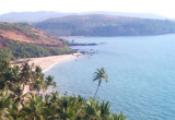
Canaguinim Bay (W India)

2.5nm
23°
Canaguinim Bay is entered between Canaguinim Point, about 1 mile SW of Betul Point, and Moliem Point, about 2 miles SW.
Two rock patches, each drying 1.2m, lie about 0.1mile and 0.3 mile, respectively, SW of  Canaguinim Point.
Cliffs, about 38m high, lie on the E half of ...
4 Mar 12
Jojo

Oyster Rocks - Mandal and Karkal islands (W India)

18nm
153°
Oyster Rocks consist of a prominent group of islands and rocks. Devgad Island (Devgadgudda Island), 44m high to the tops of the trees, is the largest and highest island; it is bold, rocky, and steep-to on its W side.
Oyster Rocks Light, with a racon, is shown from a red round masonry ...
5 Mar 12
Jojo

St George's Islands (W India)

18nm
333°
St George’s Islands consists of three islands between 1.5 and 2.5 miles SSW of Marmagao Head.
Grandi Island is the collective name of the two S islands of the group, which are connected by a narrow reef of rock and shingle.
The W of the two islands, 76m high and conical, is ...
4 Mar 12
Jojo

Binge Bay (W India)

23nm
147°
Binge Bay lies between Binaga Point and Arge Cape, 2.5 miles SE.
A restricted area, into which entry is prohibited, extends from a position about 0.5 mile SE of Karwar Head to Kwada Point.
A major naval base, which includes shipbuilding and repairs facilities, is located on ...
6 Mar 12
Jojo

Loliem (Lolien) Point (W India)

12nm
144°
Loliem Point (Lolien Point), in the N approach to Karwar, attains an elevation of 175m about 0.2 mile inland, and is steep, rocky, and well-wooded.Loliem Rocks, awash at LW springs, lie about 1 mile S of Loliem Point; a rock, with less than 1.8m over it, lies about 0.2 mile N of the ...
5 Mar 12
Jojo

Belekeri (W India)

28nm
139°
Belekeri Bay (Roads) has depths of less than 5m. Foul ground extends about 0.7 mile W of Belekeri Point, a low, flat, and rocky point at the head of the bay. Several small islets lie close N and about 0.2 mile WSW of the point.
6 Mar 12
Jojo