Santapelli rocks, with a least depth of 1.5m and dangerous wrecks close E, lie between 5.5 and 6 miles SE of Santapilli Light. The sea breaks heavily over these dangers with a moderate swell, but not in good weather. The channel between these rocks and the mainland is safe only during daylight. At night, vessels should keep in depths of over 35m when Santapilli Light bears between 322° and 290°.
The summit of an isolated bare red double-peaked hill, 117m high, about 2 miles N of Santapilli Light, in line bearing 304° with Kandivalasa Peak, leads N of Santapilli Rocks. Santapilli Light in line bearing 322° with Kandivalasa Peak, leads S of these rocks.
Konada lies at the mouth of a small river. Several white buildings and some trees lie on the N side of the river.The coast between Konada and Kalingapatam, about 37 miles ENE, consists of a sandy beach backed by low sandhills.
Bhimunipatnam lies on the S side of the mouth of the large and shallow Gostani River. Vessels anchor in the open roadstead off the town to work cargo. The town is built on the E slopes of a hill, 166m high, which is topped by some trees and a pyramidal obelisk. A white temple lies ...
Sandy Point lies about 3.5 mile E of Nanwell Point. An obstruction, with a least depth of 7.3m, was reported to lie about 1.5 miles NNE of Sandy Point.
Kalingapatnam lies close S of the mouth of the Vamsadhara River and about 1.5 miles NNW of Sandy Point. There are no berthing facilities.Kalingapatnam is known in the history as the Capital of Gang Dynasty who
ruled the region, spread over the entire coastal belt from Godavari to ...
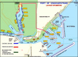
Vishakhapatnam, a port of growing importance and the fourth largest port in India, lies at the mouth of the Meghadri River, close NW of Dolphin’s Nose. Petroleum and iron ore products are the principal exports. The only shipyard in India capable of building ocean-going merchant ...


 Santapelli rocks, with a least depth of 1.5m and dangerous wrecks close E, lie between 5.5 and 6 miles SE of Santapilli Light. The sea breaks heavily over these dangers with a moderate swell, but not in good weather.