Kariya Shuli and Vilangu Shuli islets (Pattanamarudur-E India)
12nm
11°
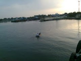
The bight is filled by a flat, with depths of less than 5.5m, extending up to about 4.5 miles offshore. Kariya Shuli and Vilangu Shuli, ...
20 Mar 12
Jojo
| Latitude | Longitude | |
| DMS | --- | --- |
| DM | --- | --- |
| DD | --- | --- |

 channel 6, 12, 14,16


 Tuticorin (Tuttukuddi) is the largest commercial town on the W side of the Gulf of Mannar.
Chidambaranar Port is an artificial deep-sea harbour formed with rubble mound type parallel breakwaters projecting into the sea for about 4 km. (Length of North breakwater is 4098.66 m, length of South breakwater is 3873.37 m and the distance between the breakwaters is 1275m).The port (Chidambaranar) is an open roadstead, well-protected by the land to the W from the Southwest Monsoon; it is available in all seasons.
The all-weather harbor of New Tuticorin, about 0.5 mile S of Tuticorin, handles the majority of cargo for the port. The port is protected on its N side by North Breakwater, which is 2.3 miles long, and on its S side by South Breakwater and Eastern Breakwater.
The rocky sea bottom, making dredging closer inshore impossible, necessitates these long breakwaters.
Natural depths of 11m become available only at a distance of approximately 2 miles from shore.
The entrance to the harbor lies 3 miles SE of Pandyan Tivu Light.
Tuticorin also has a passenger terminal for ferry services between the port and Colombo, Sri Lanka.
The tidal rise at Tuticorin is 1m at MHWS and 0.7m at near HWN.
The currents along the coast, outside the islands near Tuticorin, generally set with the wind, varying in strength from 1 to 2 knots. They are weak and variable at the change of the monsoons.
When there is a lull in the monsoon, there is a tendency for current to set into, instead of across, the Gulf of Mannar.
The tidal currents at Tuticorin set in a N direction with the flood tide and in a S direction with the ebb.
The approach channel, which is 2,400m long and 183m wide, is dredged to a depth of 12.5m.
The turning basin, which is just inside the breakwaters has a depth of 11.9m and is 500m in diameter.
A drying reef extends up to 0.5 mile E of Pandyan Island.
Orripar, a rock shoal with a least depth of 0.9m, lies about 0.3 mile N of Pandyan Island.
Kariapar, a rocky pinnacle with a depth of 1.5m, lies about 0.8 mile NE of the NE extremity of Pandyan Island. Rocky pinnacles, each with a depth of 1.5m, lie about 0.2 mile E and 0.5 mile ENE, respectively, of Kariapar.
Van Tivu, about 2.8 miles NNE of Pandyan Tivy, lies on a reef which extends about 0.5 mile NE and 0.4 mile SE from it.
A beacon, 10m high, lies on the S extremity of Van Tivu.
A boat channel, about 137m wide, marked by lighted buoys and a lighted range, leads to the old piers at Tuticorin from a position about 1.8 miles NE of the N end of Pandyan Island.
The least depth alongside the piers and wharves at Tuticorin is 2.4m.
Tel: (0461) 2352290
Fax: (0461) 2352301
Mail: tutport@sancharnet.in
The vessel’s ETA should be sent, via the agent, 72 hours and 24 hours in advance and confirmed or amended no less than 6 hours in advance.
The ETA messages should contain the following information:
4.6 Vessels must contact the signal station 1 hour prior to arrival and upon arrival on VHF channel 12 or 16.
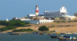
A signal station, with a flagstaff 29m high, lies on the N end of Pandiyan Island. This station, manned day and night, is connected to the mainland by telephone. Communication is by International Code of Signals.
Storm signals are displayed from the signal station; the General System is used.
Several wrecks and foul ground lie between 1.5 and 2.3 miles E and ESE of Pandiyan Island Light.
Ebook | Bay of Bengal
|