Karaikal Port (Tamil Nadu-E India)
4.6nm
1°
The port is privately operated by Karaikal Port Private Limited (KPPL) and is located between the Pravadayanar River and the Vettar ...
25 Mar 12
Jojo
| Latitude | Longitude | |
| DMS | --- | --- |
| DM | --- | --- |
| DD | --- | --- |

 Nagapattinam (Negapatam), the principal port of the Thanjavur District, lies at the mouth of the Uppanar River.
Vessels anchor in the roadstead off the port to work cargo.All cargo is handled at the anchorage by lighters. About 114 of
these lighters are available, each with a capacity of 40 tons.During the Northeast Monsoon, the predominant wind is from the NE at a force of 6 to 7. The port is closed to shipping at this time. During the Southwest Monsoon, the wind is W a force 6.
In general, the currents off Nagapattinam set with the wind and vary with its direction and force.
The tides off the port are semidiurnal.
The 10m curve lies about 2 miles off the port; the depths shoal gradually toward the shore.
There is a least depth of 1.2m over the bar which crosses the mouth of the Uppanar River. The river channel leading to the river quays has a dredged depth of 2.4m. Cargo lighters must have a draft of less than 1.2m to cross the bar and enter the river.
The sea breaks over the bar in nearly all weathers and crossing can be dangerous for boats unless carefully handled. Boats are not permitted to cross the bar after dark.
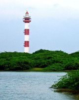
A minaret at Nagore, 46m high, about 3.3 miles N of Nagapattinam, can be seen before the adjacent coast becomes visible. Upon closer approach, Nagapattinam Light, the tall church spire to the NW and two chimneys at the railway workshop to the SW, are conspicuous from the offing.
Nagapattinam has been reported to be a good radar target up to 17 miles.
Vessels should send their ETA to their local agent 48 hours in advance.
A signal station which vessels at anchor can communicate with using the International Code of Signals by day, and the Morse Code by night, is located 0.1 mile NNE of the old lighthouse. Flags of the International Code of Signals are displayed from the station to assist vessels in anchoring on the most suitable bearing from the lighthouse; Flag K indicates a bearing of 260°, with each subsequent letter indicating a 5° increase to Flag Q, which indicates a bearing of 290°.
Storm signals are displayed from the lighthouse in accordance with the Indian Extended System.
The port can be contacted, as follows:
1. Call sign: Nagapattinam Port Radio
2. VHF: VHF channels 11, 13, 14, and 16
3. Telephone: 91-4365-22255 or 91-4365-22363
4. Telegraph: PORT OFFICE NAGAPATTINAM
The anchorage off Nagapattinam is open to all but W winds; the holding ground of mud and sand is good.
Vessels usually anchor according to drafts and the state of the weather, with the lighthouse bearing between 290° and 260°.
Vessels of moderate draft can take good anchorage, in a depth of 7.8m, about 1.3 miles E of the lighthouse. In heavy weather, a short broken sea is encountered; during the Northeast Monsoon it is inadvisable to anchor in depths of less than 9.1m.
")
") Nagapattinam lighthouse
Nagapattinam lighthouseEbook | Bay of Bengal
|