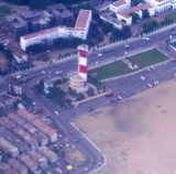
The Lighthouse station is separated from Pulicat town by a sea water channel. The town of Pulicat lies on an island at the S end of Pulicat Lake and is visible from the offing. A tall conspicuous monument lies close N of the lighthouse near the beach.
The lighthouse at this site is meant to warn against the existence of a
shoal about 4 NM from the shore. The shoal extends more than 9 NM toward
south. The LH expert Mr Alan D Stevenson on his visit to this lighthouse in
1926 observed the light to be extremely low powered for the purpose of
marking such danger. Besides he also mentioned about frequent Malarial
attacks infesting the station.
The coast between Pulicat and Point Pudi, about 22 miles NNW, is marked by casuarina plantations for about 11 miles N of Pulicat Lake. A conspicuous clump of coconut trees, 24m high, lies on a sand hill about 1 mile S of Point Pudi.
Pulicat Shoals, a chain of hard, sandy patches with depths ranging from 4.3 to 9.1m, extends about 7.5 miles NNE from the N end of Ennur Shoal. Several detached patches, with depths of 8.2 to 11m, lie within 3.8 miles N and NNW of the N end of Pulicat Shoals. These shoals were ...
Ennur Shoal, with depths of 0.9 to 8.5m, extends 2.5 miles NE from a position on the coast about 10.5 miles NNE of Chennai Harbor. The coast between Chennai and Ennur, about 9.5 miles NNE, is bordered by plantations of casuarina and palm trees.
Ennore Port, about 24 km north of Chennai Port, is the first port in India which is a public company. Ennore Port lies on the northeastern corner of the state of Tamil Nadu on a flat coastal plain known as the Eastern Coastal Plains, on the Coromandel coast.Depths—LimitationsThe ...
Chennai Port, formerly known as Madras Port, is the second largest port of India, behind the Mumbai Port, and the largest port in the Bay of Bengal and the principal harbor of Coromandel coast.
It is an artificial and all-weather port with wet docks that front s the center ...
The Madras Light House is a lighthouse facing the Bay of Bengal. It is a famous landmark on the Marina Beach in Chennai. The lighthouse was opened in January 1977. It is one of the few lighthouses in the world and the only one in India with an elevator. The currents N of Chennai ...


 The Lighthouse station is separated from Pulicat town by a sea water channel.
")