Dumai harbour (E Sumatra)

Dumai harbour (E Sumatra)

Per individuare con precisione. Aggiornare se necessario.

Localizzazione

Dumai harbour (E Sumatra)
LatitudeLongitude
DMS------
DM------
DD------

Caratteristica

VHF chennal 12
Porto commerciale

Descrizione

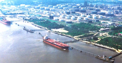
Dumai is a seaport town situated on the S side of Selat Rupat on the mainland coast of Sumatera directly opposite Tanjung Kapal. Dumai is an important oil loading terminal, with facilities for loading general cargo.
This is one of the main entry points into Sumatra by boat. Dumai is very busy with most of the oil of Sumatra exiting from it's seaport.

Tides—Currents

The average range of the spring tides is about 2.4m; the average range of the neap tides is 1.7m.
The current sets parallel to the faces of the wharves with the flood setting to the E at a rate of 3 knots and the ebb setting to the W at a maximum rate of 2 knots. There is no slack period at springs and neaps. Tidal signals are displayed from the oil wharf at the port of Dumai.
Two fixed red lights horizontally disposed indicate an E current; two fixed white lights, horizontally disposed, indicate a W current. Red and white balls are used in lieu of the lights during the day time.

Depths—Limitations

The Dumai port area can be reached by deep-draft vessels by proceeding from the Strait of Malacca into Selat Bengkalis and following a buoyed channel on a S course for about 22 miles to the junction of Selat Rupat.
Vessels must make a turn of about 180° to enter Selat Rupat and then follow a W course for a distance of 33 miles to Dumai.
The Selat Bengkalis and the Selat Rupat fairways have been wire-dragged to a depth of 24m and 18.3m, respectively.
Incoming ships are assigned berths in accordance with time of arrival, product to be loaded, size of vessels, and loaded draft.

There are many wharves available at Dumai. One wharf is Pertamina-owned and consists of two berths. Another wharf is the Pertamina Product Jetty and consists of four berths. The other four wharves are Chevron-owned and operated.

Pilotage

Pilotage for Selat Rupat, Selat Bengkalis, and Lalang Terminal is compulsory and is available 24 hours. The pilot boards N of Fairway Lighted Buoy. Vessels should send ETA through Dumai (PKP) 96 hours and 24 hours in advance, notifying of any changes of over 3 hours immediately.

Vessels also need to state if proceeding through Singapore and send an amended ETA upon leaving there. Vessels should contact Morong Pilot Station on VHF channel 16 requesting a pilot at the fairway buoy.

Harbor pilotage is compulsory for all vessels entering the inner harbor at Dumai. The ETA must be sent 6 hours in advance.
Harbor pilots are available 24 hours.
Pilots will board vessels at the cargo (berthing) anchorage in position 1°42.5'N, 101°26.0'E, or on arrival at Buoy 18 if a berth is available. Harbor pilotage is performed by government pilots.
All vessels proceeding to Dumai should hoist the International Code Flag “H” or “PT” when passing Buoy 17 and call Chevron on VHF channel 12. At this time the vessel will be notified if pilots are available; if not, then the vessel may proceed directly to Dumai Harbor Anchorage Area.

Regulations

The Rupat Strait/Bengkalis Strait area has been designated as a restricted maritime zone by Indonesia. A partial exemption from the requirement to secure special Indonesian Consular clearance prior to entering this zone has been granted by the Indonesian navy to tankers bound for Dumai from any port in the world except Singapore.
Vessels require only normal clearance from their last port to obtain entry at Dumai. Vessels diverted at sea need only normal clearance from the last port and the diversion cable.
All vessels inbound to Dumai from abeam of Raleigh Bank Lighted Buoy until anchored off Dumai must display the International Code Flag hoist “CAL” flown from the signal yard, by day; and a red light, 1.8m above a white light, by night.

Anchorage

The Dumai general anchorage is N and W of the oil wharves. The least depth in this area is 14.6m. Holding ground at these anchorages is good, with clay bottom.
It is reported that this area is sufficient enough for ease of maneuvering and will provide swinging room for several vessels of the size that are accommodated at the oil wharves.
2012/01/25
Aggiornare
Jojo
Dumai harbour (E Sumatra)
2012-01-25
Aggiornare
Jojo
Ebook

Sumatra (Indonesia)

  • 326 sites
  • 109 photos
  • publication date: 7 Aug 2024
  • .pdf file size: 109 Mb
Condividi i tuoi commenti o le foto su "Dumai harbour (E Sumatra)"

Siti intorno a Dumai harbour (E Sumatra)

Flying distances - Direct line

Selat Rupat (Selat Dumai) (E Sumatra)

1.5nm
314°
Selat Rupat (Selat Dumai) separates Pulau Rupat from the mainland of Sumatera. Tanjung Ketam, the W entrance point of the N end of Selat Rupat, is low and sandy and is marked by some houses and coconut trees.
25 Jan 12
Jojo

Pyramid shoal (Malaysia)

44nm
Pyramid Shoal, which lies on the N side of the SE end of South Sands, has a least depth of 3.4m, hard sand, and is the most dangerous shoal in the area because of its depth and protrusion into the fairway.
A lighted buoy is moored about 7 miles SE of Pyramid Shoal. A depth of about ...
28 Dec 11
Jojo

Water islands (Malacca - Malaysia)

56nm
65°
Between Melaka and Tanjong Seginting, about 46 miles SE, the low, thickly wooded coast is bordered by a mud bank which extends up to 2.5 miles offshore in places.
The Water Islands, centered about 8 miles SE of Melaka, consists of a group of six tree-covered islands of moderate ...
5 Jan 12
Jojo

Selat Bengkalis (E Sumatra)

31nm
105°
Selat Bengkalis lies between the SW side of Pulau Bengkalis and Sumatera and is entered W of Tanjung Jati, the W extremity of Pulau Bengkalis, which stands about 19 miles SE of Tanjung Masim. The N approach is deep and presents no difficulty if the buoyed channel is followed.
The ...
25 Jan 12
Jojo

Raleigh shoal (NE Sumatra)

34nm
44°
Raleigh Shoal, about 4 miles long in a NW to SE direction with a least depth of 4.8m, lies centered about 15 miles E of Tanjung Medang.
A shoal, with a depth of 19.4m, was reported to lie 3.5 miles NNW of Raleigh Shoal. A lighted buoy is moored on the S side of the shoal. There ...
29 Dec 11
Jojo

Vowler Bank (E Sumatra)

45nm
78°
Vowler Bank, with depths of less than 20m, lies with its NW end about 5 miles SE of the 2.4m depth on Rob Roy Bank. A 9.1m patch lies near the NW end of the bank and a similar depth lies s about 3 miles SE.
29 Dec 11
Jojo