Pulau Wunga, about 8 NM S of Pulau Mausi, is low andcovered with coconut trees. A large conspicuous tree, visible for 16 miles, is located on a small elevationnear the N end. The reef extending from the N side of the island is ordinarily marked by high rollers; on the S side ...
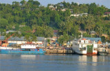
Gunung Sitoli (Gunungsitoli is the capital and the port of Nias. It is located about 14 NM NW of Tg Lambaru and forms a deep bight. At its head the hills approach the shore, leaving a strip of lowland between them. 6.29 The mouth of the river, leading to the port, will just ...
Tanjung Laaja is the N end of the slope of a hill backing the coast. It is covered with coconut trees, steep-to, and free from dangers but is difficult to identify.
Pulau Mausi, low and barren, lies in the S approach to Labuan Atjeh, about 2.2 miles SE of Tanjung Sosilutte. It has a white sandy beach, and is fringed by a reef onwhich the sea always breaks, extending about 1 mile S; there is a depth of 7.7m at the outer end of the reef. An ...
Pulau Sarangbaung lies 10.5 miles NNE of the N extremity of Pulau Nias. There is a break in the reef on the SE side where boats can land at a village. The island is overgrown with coconuts and is visible for 12 miles.
Tanjung Lambaru, located about 8 miles NW of Ujung Onolimbu, is swampy and thickly overgrown; dead trees stand on it and in the water close off it.At Tanjung Lambaru it has a width of 8 miles. The coast consists of a sandy beach, off which rocks are lying. The sea usually breaks, ...


 North of Gunungsitoli, the coast is covered with coconut trees for about 6 miles.