Caleta Buena, at the foot of a bluff about 3.5 miles SSE of the Isla Peninsula, is exposed but free from danger. Several rocks lie close off the shores of the cove and a rock, awash, lies about 151m offshore.
Caleta Buena was formerly a place of shipment for nitrates, but the piers have been demolished and the buildings and installations are in ruins. The nitrate slides falling from the plateau S of the cove and a prominent cemetery at its N end serve as good marks.
Anchorage in 18/20 m, a little over 0.3 mile offshore. The anchorage is somewhat protected from the S winds.
2012/12/14
Update
Joëlle
Título / alt: Fecha de tiro: Fotógrafo: Descripción:Su nombre o pseudo
2012-12-14
Update
Joëlle
Caleta Buena se trouve au pied d'une falaise à environ 3,5 MN au SSE de Isla Peninsula. Elle est exposée, mais sans danger. Plusieurs rochers se trouvent à proximité, au large des côtes de la baie et un rocher, submergé, se trouve à environ 151 m au large.
Caleta Buena était autrefois un lieu d'extraction et d'expédition de nitrate, mais les quais ont été détruits et les bâtiments et les installations sont en ruine. Le nitrate qui glissait sur le plateau S de l'anse et un cimetière au premier plan à l'extrémité N de l'anse sont remarquables.
On peut ancrer par 18 à 20 m, à environ un peu moins de 0,3 MN de la côte. Le mouillage est un peu protégé des vents du S.
Iquique bay lies between Punta Piedras and Serrano peninsula, 3 NM S.Bahia de Iquique is open to winds between the NW and NE, however, these winds seldom occur. Iquique is ordinarily entirely free from storms of any kind and strong winds are very unusual. The light breezes are ...
Isla Peninsula lies on the S entrance point of Mejillones del Norte cove and is joined to the mainland at its NE end. Close off the N side are a number of submerged rocks and an islet.
Caleta Mejillones del Norte can be recognized easily from the N by a road which passes over the hills backing it and by Quebrada de la Aurora, a ravine a little to the S. Peninsula island and Mejillones islets are located off the coast, S cove.It is possible to anchor off the entrance ...
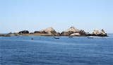
Islotes Mejillones are nearly 0.5 mile SW of the Isla Peninsula. They consist of three large and several smaller rocks of whitish color.The passage between them and the Isla Peninsula has depths of 10.1 to 14.6m, but there is a rock awash in the middle of the passage, and it should not be attempted.


 good holding


 Caleta Buena, at the foot of a bluff about 3.5 miles SSE of the Isla Peninsula, is exposed but free from danger. Several rocks lie close off the shores of the cove and a rock, awash, lies about 151m offshore.
 ") Título / alt: Fecha de tiro: Fotógrafo: Descripción:Su nombre o pseudo
Título / alt: Fecha de tiro: Fotógrafo: Descripción:Su nombre o pseudo  Caleta Buena se trouve au pied d'une falaise à environ 3,5 MN au SSE de Isla Peninsula. Elle est exposée, mais sans danger.
")
")