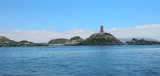
Bahia de Copiapo (Atacama N Chile)
15nm
199°
Copiapo was once a shipping ore port, but it is no longer used such as such because of the poor anchorage and landing ...
9 Jan 13
Joëlle
| Latitude | Longitude | |
| DMS | --- | --- |
| DM | --- | --- |
| DD | --- | --- |

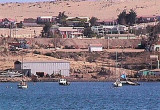
 Caleta Calderilla is about 2 NM S Punta Caldera lighthouse, between Punta Zorro and Punta Caldereta.
A beacon is situated on Punta Zorro and a light is shown from Punta Caldereta.
The E and S shores of the cove are bordered by shallow water and dangers, which lie up to 0.3 mile offshore. Peninsula Ester, formerly Islote Ester, is connected to shore by a causeway and lies about 0.2 mile offshore in the S part of the cove.
An ore terminal is situated on the NE side of Peninsula Ester.
A pontoon pier, used for the production of fish meal, lies 0.5 mile NE of Peninsula Ester.
")
 Caleta Calderilla se trouve à environ 2 MN au S du phare de Punta Caldera, entre Punta Zorro et Punta Caldereta.
Des rochers qui s'étendent à plus de 0,1 MN de chacun de ces points rétrécissent l'entrée de l'anse à environ 0,3 MN.
Une balise se trouve sur punta Zorro et un phare se trouve sur Punta Caldereta.
Le rivage E et S de l'anse est bordé par des dangers et de l'eau peu profonde, qui s'étendent jusqu'à plus de 0,3 MN au large.
La péninsule Ester, islote Ester à l'origine, est reliée à la terre par une chaussée et s'étend à environ 0,2 MN au large dans la partie S de l'anse.
Un terminal minéralier se trouve situé sur le côté NE de la péninsule Ester.
Un quai utilisé pour la production de farine de poisson se trouve à 0,5 MN au NE de la péninsule Ester.
")
Ebook | Chile
|