Canaguinim Bay (W India)

Canaguinim Bay (W India)

To precisely geolocate this site. Update if necessary.

Localisation

Canaguinim Bay (W India)
LatitudeLongitude
DMS------
DM------
DD------

Characteristics

Mooring
Sand
Beach
Sand

Description

Canaguinim Bay is entered between Canaguinim Point, about 1 mile SW of Betul Point, and Moliem Point, about 2 miles SW.

Two rock patches, each drying 1.2m, lie about 0.1mile and 0.3 mile, respectively, SW of  Canaguinim Point.
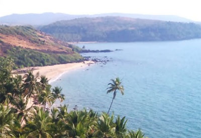
Cliffs, about 38m high, lie on the E half of the bay. A rocky islet, 0.9m high, lies at the head of the bay.
Anchorage can be taken, in 9.1m, 0.5 mile NNE of Moliem Point.
2012/03/4
Update
Jojo
Canaguinim Bay (W India)
2012-03-04
Update
Jojo
Ebook

Arabian Sea

  • 132 sites
  • 73 photos
  • publication date: 6 Jul 2023
  • .pdf file size: 49 Mb
Share your comments or photos on "Canaguinim Bay (W India)"

Sites around Canaguinim Bay (W India)

Flying distances - Direct line

Rama cape (W India)

2.5nm
203°
The coast between Khanderi Island and Cape Rama, about 228 miles SSE, consists of sandy bays separated by bold rocky capes.
There are a number of river estuaries and it is often bordered by tableland in the middle of its S part.The Western Ghats, which are generally from 609 to ...
4 Mar 12
Jojo

St George's Islands (W India)

16nm
326°
St George’s Islands consists of three islands between 1.5 and 2.5 miles SSW of Marmagao Head.
Grandi Island is the collective name of the two S islands of the group, which are connected by a narrow reef of rock and shingle.
The W of the two islands, 76m high and conical, is ...
4 Mar 12
Jojo

Oyster Rocks - Mandal and Karkal islands (W India)

19nm
158°
Oyster Rocks consist of a prominent group of islands and rocks. Devgad Island (Devgadgudda Island), 44m high to the tops of the trees, is the largest and highest island; it is bold, rocky, and steep-to on its W side.
Oyster Rocks Light, with a racon, is shown from a red round masonry ...
5 Mar 12
Jojo

Cola Bay (W India)

14nm
344°
The coast between Cola Bay and the Sal River, about 14 miles SSE, consists of low cultivated land with several churches on small hills.
Anchorage, sheltered from NW winds, can be taken, in a depth of about 7m, in Cola Bay.
4 Mar 12
Jojo

Binge Bay (W India)

24nm
152°
Binge Bay lies between Binaga Point and Arge Cape, 2.5 miles SE.
A restricted area, into which entry is prohibited, extends from a position about 0.5 mile SE of Karwar Head to Kwada Point.
A major naval base, which includes shipbuilding and repairs facilities, is located on ...
6 Mar 12
Jojo

Loliem (Lolien) Point (W India)

13nm
153°
Loliem Point (Lolien Point), in the N approach to Karwar, attains an elevation of 175m about 0.2 mile inland, and is steep, rocky, and well-wooded.Loliem Rocks, awash at LW springs, lie about 1 mile S of Loliem Point; a rock, with less than 1.8m over it, lies about 0.2 mile N of the ...
5 Mar 12
Jojo