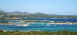
Nibani islands (meaning "seagull") consisting of three major islands and numerous rocks are located on the north-eastern coast of Sardinia, SE Porto Cervo.
They are part of the International Park of Bonifacio.
These islands are home to many seagulls that give its name to the island.
2012/09/17
Update
Joëlle
Les îles Nibani (qui signifie "mouette") constituées de trois îles majeures et de nombreux rochers, sont situées sur la côte nord-orientale de la Sardaigne, au SE de Porto Cervo.
Elles font partie du Parc International des Bouches de Bonifacio.
Ces îles abritent de nombreuses mouettes qui donnent son nom à l'île.
2012/09/17
Update
Joëlle
Li Nibani (che significa "gabbiano") costituito da tre isolotti maggiori e da vari scogli, sono situate nella costa nord-orientale della Sardegna, a SE di Porto Cervo.
Gulf of Arzachena (Arsachena), located between Punta Saline and Tre Monti Cape, is a high inlet whose banks are lined with shoals. S tip, Arzachena, W of the entrance, a beacon consists of an iron post with a sheer spherical white marks a rock particularly ...
It is the largest island of the archipelago composed of sixty islets and 7 major islands, in the NE end tip of Sardinia. It is mountainous and arid. This is the only inhabited island thoroughly. It is connected by a bridge to Caprera island where are the house and the tomb of Garibaldi. ...
Tavolara island is a limestone massif 6 kilometres long and 500 m wide, and 565 m high.The overhanging cliffs make it inaccessible, with the exception of a bay and a beach that is located at each end of the island, Spalmatore di Fuori northeast (military zone) and Spalmatore di Terra ...
Degli Aranci gulf is is bounded, on the N, by the peninsula of which Capo Figari is the E extremity.This gulf is sheltered from NE and NW winds. Strong SE winds send in a heavy sea and storms from the N and E cause a considerable swell in the gulf. During offshore winds, which are ...
This gulf is S Cugnana gulf, S cala della Volpe. It is entered between Punta della Volpe and Punta Canigione.This gulf is the most protected area of the coast. Although the anchorage is prohibited in the Gulf because of submarine telegraph cables, many boaters anchor in this ...
Passo delle Galere lies between isole di Nibiani and the mainland. It is 0,1 NM wide and has a depth of 9 m. It is without difficulty if you stand in the center. It's the safest way between the islands and the mainland.


")
 Nibani islands (meaning "seagull") consisting of three major islands and numerous rocks are located on the north-eastern coast of Sardinia, SE Porto Cervo.
 Les îles Nibani (qui signifie "mouette") constituées de trois îles majeures et de nombreux rochers, sont situées sur la côte nord-orientale de la Sardaigne, au SE de Porto Cervo.
 Li Nibani (che significa "gabbiano") costituito da tre isolotti maggiori e da vari scogli, sono situate nella costa nord-orientale della Sardegna, a SE di Porto Cervo.