Krishnapatnam port (Andra Pradesh-E India)

Krishnapatnam port (Andra Pradesh-E India)

To precisely geolocate this site. Update if necessary.

Localisation

Krishnapatnam port (Andra Pradesh-E India)
LatitudeLongitude
DMS------
DM------
DD------

Characteristics

Harbour

Description

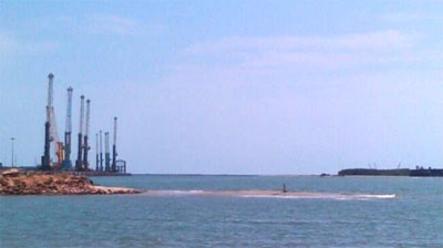
Krishnapatnam or Kistnapatam is a port town in Muthukur mandal of Nellore district in Andhra Pradesh.

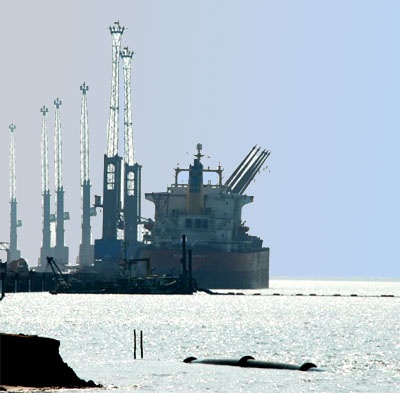
Krishnapatnam is a major port and market center. It is situated at a distance of 24 km from Nellore City in Nellore District, the southernmost coastal district in the state of Andhra Pradesh, 200 kilometer north of Chennai. It has handled 30 million tonne of cargo in its first 12 months of operations. 10 deep water berths are operational at the port now,(for coal, iron ore and general cargo) and 2 breakwaters. It will soon have additional 35 berths, with facilities to handle containers etc.

Krishnapatnam is one of the very few ports in the world which can handle giant ships with load capacities of 1,50,000 tonnes. It has became one of the deepest port of India with 18 meters of draft.

Depths—Limitations

There are four berths with maximum depths of 15m alongside. Two berths handle coal, one handles iron ore and one handles general cargo. The port plans on eventually expanding to 17 more berths in two phases.

Pilotage

Pilotage is compulsory. Pilots board vessels with drafts less than 10m at Pilot Boarding Station A, in position 14°14.5'N, 80°12.5'E. Pilots board vessels with a draft of 10m or greater at Pilot Boarding Station B, in position 14°14.9'N, 80°15.3'E.

Regulations

Vessels should report their ETA to Port Operations 7 days, 5 days, 48 hours, and 24 hours, in advance.

The ETA message should contain the following information:
1. Draft forward and aft.
2. ETA at the pilot boarding station.

Signals

Storm signals are shown; the Brief System is used.

Casuarina plantations line the coast up to 3 miles N of the mouth of the Upputeru River, then abruptly changes to sand hills for 5 miles and becomes low and sandy as far N as the Penner River, about 13 miles farther N.
2012/03/28
Update
Jojo
Krishnapatnam port (Andra Pradesh-E India)
2012-03-28
Update
Jojo
Krishnapatnam port (Andra Pradesh-E India)
2012-03-28
Update
Jojo
Ebook

Bay of Bengal

  • 110 sites
  • 82 photos
  • publication date: 8 Aug 2024
  • .pdf file size: 55 Mb
Share your comments or photos on "Krishnapatnam port (Andra Pradesh-E India)"

Sites around Krishnapatnam port (Andra Pradesh-E India)

Flying distances - Direct line

Shallinger Shoal (Andra Pradesh-E India)

10nm
28°
Shallinger Shoal, a spit with depths of 3.2 to 4.6m, extends about 2.5 miles NE from the coast, 7.5 miles N of the mouth of the Upputeru River. A detached 5.5m patch lies 1.5 miles S of the NE extremity of Shallinger Shoal.
28 Mar 12
Jojo

Armagon light (Andra Pradesh-E India)

21nm
169°
Armagon Light is shown from a white round concrete tower with red bands, about 30m high, lying near the coast 7 miles NNW of Point Pudi.
28 Mar 12
Jojo

Armagon shoal (E India)

25nm
164°
Armagon Shoal, with depths ranging from 3 to 9.1m, extends about 15 miles N from a position 1.5 miles NE of Point Pudi.
A narrow, detached shoal, about 2.5 miles long, with depths of 10 to 11m, lies close N of the N end of Armagon Shoal. The sea sometimes breaks over the shallowest ...
26 Mar 12
Jojo

Ramaypatnam Lighthouse (Andra Pradeh-E India)

48nm
353°
Ramaypatnam Light, from which a radiobeacon transmits, is shown from a hexagonal concrete tower lying on the coast 0.8 mile NE of the church at Ramaypatnam, built in 1870, that served as a land mark for the benefit of ships cruising off the Ramaypatnam coast.
The Lighthouse Tower ...
28 Mar 12
Jojo

Pulicat lighthouse (Tamil Nadu-E India)

50nm
167°
The Lighthouse station is separated from Pulicat town by a sea water channel.
The town of Pulicat lies on an island at the S end of Pulicat Lake and is visible from the offing. A tall conspicuous monument lies close N of the lighthouse near the beach.
The lighthouse at this ...
28 Mar 12
Jojo