Gradac (Dalmatia Central) is located at the S end of the Makarska Riviera (40 km from Makarska), halfway between Split and Dubrovnik. Gradac is located in a bay 5 NM NW of Rt Visnjica. The harbor is very shallow and narrow. You can anchor outside the breakwater by 5 to 10 m, taking care to flooded blocks overflowing the end of the breakwater.
2011/05/4
Update
Jojo
Gradac (Dalmacie centrale) est situé à l'extrémité S de la rivièra de Makarska (40 km de Makarska), à mi-chemin entre Split et Dubrovnik. Gradac se trouve dans une baie à 5 NM au NW de Rt Visnjica.
Le petit port est très peu profond et exigü.
On peut mouiller au brise-lames extérieur par 5 à 10 m en faisant attention aux blocs submergés débordant l'extrémité du brise-lames.
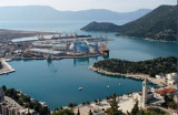
The narrow sea from Zaliv Klek Neum is 4 NM long and lies at the NE channel Malog Stone. It is surrounded by mountains and is inserted between Rt Rep Kleka and Rt Meded. Depths exceeding 20 meters in most cases. There are several anchorages. The SE part and W peninsula ...
Skoji is a group of islands in Korcula Archipelago, located in Peljesac Channel in Croatia. There are all together 19 small islands that form this archipelago. Their names are : Badija, Kamenjak, Gojak, Planjak, Vrnik, Majsan, Majsanic, Gubavac, Knezic, Bisace, Sutvara, Stupe, Baretica, ...
Luka Kardeljevo, an inlet, lies in the N part of the delta area of Rijeka Neretva, a large river. The town of Kardeljevo is situated in the E part of the inlet and is connected to the inland regions by barge canal. The commercial port lies on the E side of the inlet. There ...
Uvala Drevnik is a small bay with a small fishing port on one side and a pier for the ferry that links with O. Hvar, on the other side. You can anchor in the bay, by 7 m. Sheltered N and E.
Rt Sucuraj, the E extremity of Otok Hvar, lies 2.5 miles from the mainland coast. This point is low and a chapel is situated on it. A light is shown from a prominent structure, 14m high, standing on the point.


 Gradac (Dalmatia Central) is located at the S end of the Makarska Riviera (40 km from Makarska), halfway between Split and Dubrovnik.
 Gradac (Dalmacie centrale) est situé à l'extrémité S de la rivièra de Makarska (40 km de Makarska), à mi-chemin entre Split et Dubrovnik.