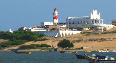
Manappad Point is a high sandy promontory with a rock base. A light is shown from a white, round concrete tower with red diagonal stripes.
The village of Manappad lies 0.8 mile W of the point.
Manappad Outer Shoal, with a least depth of 6.4m, lies about 8 miles SE of Manappad Point. A 13.4m shoal, reported in 1976, lies about 6 miles farther E. Other shoals lie WNW and WSW. Vessels should avoid passing through this area, and in thick weather should not get into depths less than 35m.
The coast between Manappad Point and Tuticorin is low, sandy, and fringed with coconut trees.
Between Manappad Point and the village of Alantalai (Alendal), about 5.5 miles NNE, an area of foul rocky ground extends about 2.8 miles offshore. There are heavy breakers over this area during the Northeast Monsoon; these breakers extend 1 mile SE of Manappad Point.
Alendal Shoals, with depths of 3.7m, extend to about 4 miles ESE of Alantalai.


 Manappad Point is a high sandy promontory with a rock base. A light is shown from a white, round concrete tower with red diagonal stripes.


