Bravone is located int the Costa Serena, a unique region, between sea and mountains, halfway between Bastia and Porto-Vecchio, at the mouth of the riverTavignano, closes S of the lagoon. This is a small seaside resort along the beach Linguizetta (name of town).
It is possible to anchor, for a lunch break.
2012/05/3
Update
Jojo
Bravone est situé dans la Costa Serena, une région unique, entre mer et montagne, à mi chemin entre Bastia et Porto-Vecchio, à l'embouchure du fleuve Tagninano, au S du lagon. C'est une petite station balnéaire le long de la plage de Linguizetta (nom de la commune).
On peut y mouiller pour une pause déjeuner, par beau temps.
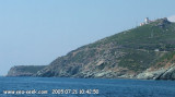
Capo Sagro is located at 11 NM. S Finocchiarola islands. He has a signal station and a semaphore rises N of it. Mount Merizatodio, 778 m high, is 1.5 MN to W Cape and dominates the immediate area.
The village of Erbalunga, situated 1.5 miles SSW of Capo Sagro, stands on the S ...
Beautiful lagoon just north of Bastia, famous since antiquity for its oyster production: it has even, in the center of the lagoon, an island built of oyster shells!
Some fish species grow there before joining the waters of the Mediterranean, the conservatory littoral has bought ...
This lighthouse, commissioned in 1864, is located two kilometers inland to the tips of Alistro, at 1300 m. But report no particular danger, yet it is an essential reference point between Bastia and Solenzara, flat area and lagoon. The tower, ...
Capraia is one of the seven islands of the Tuscan Archipelago, on the road between Cape Corsica and Elba. It is an island of 335 inhabitants (the Capraiesi) of the Province of Livorno. It lies 64 km from Livorno, 37 km from Gorgona and 31 km from Corsica. Its area is 19 km2. It has ...


 Bravone is located int the Costa Serena, a unique region, between sea and mountains, halfway between Bastia and Porto-Vecchio, at the mouth of the riverTavignano, closes S of the lagoon. This is a small seaside resort along the beach Linguizetta (name of town).
 Bravone est situé dans la Costa Serena, une région unique, entre mer et montagne, à mi chemin entre Bastia et Porto-Vecchio, à l'embouchure du fleuve Tagninano, au S du lagon. C'est une petite station balnéaire le long de la plage de Linguizetta (nom de la commune).


