Pulau-Pulau Aruah (E Sumatra)

Pulau-Pulau Aruah (E Sumatra)

To precisely geolocate this site. Update if necessary.

Localisation

Characteristics

Island / Atoll
Lighthouse

Description

Pulau-Pulau Aruah (Aruah Islands) is composed of two groups of small islands and some off-lying rocks which are located on a bank with depths of less than 20m. The S end of the bank joins an extensive mud bank lying adjacent to the Sumatera coast.

Batu Utara (2°55'N., 100°36'E.), the northernmost islet of the group, is about 4.6m high and has a reef extending N.
Batu Byms (Byms Rock) (2°54'N., 100°35'E.), awash, lies about 2 miles SSW of Batu Utara. The charted position is approximate.
Pulau Jemur (2°53'N., 100°34'E.), 22m high, flat, and treecovered, stands about 3 miles SSW of Batu Utara.

Kalironggo Islet stands on a reef about 0.3 mile NE of Pulau Jemur, and a drying reef lies about 0.5 mile farther NE.
A round islet, about 50m in diameter and surrounded by a reef about the same distance in width, stands 0.3 mile SE of Pulau Jemur Light.

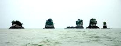
A group of five islets lie on a bank, with depths of less than 10m, which lies a little over 0.5 mile WSW of Pulau Jemur and extends in a NNW and SSE direction.

Tokong Mas (2°53'N., 100°33'E.), the northernmost of the group, is 31m high, several drying reefs lie within 0.4 mile N of Tokong Mas. Pasir Pandan, 20m high, and Sarong Alang, 27m high, stand on the same reef S of Tokong Mas.

Labuan Bilik, 20m high, stands about 137m SE of Sarong Alang.
Tokong Sipotjong lies about 0.3 mile SSE of Labuan Bilik.
A drying reef lies between the two.

Batu Berlayer (2°52'N., 100°38'E.), a group of six low rocks, surrounded by a reef, lies about 3 miles E of Pulau Jemur.
Half Tide Rock (2°52'N., 100°40'E.), which dries 2.4m and is steep-to, lies about 2 miles E of Batu Berlayer.
Batu Mandi (2°52'N., 100°41'E.), 2m high and steep-to, lies 7 miles E of Pulau Jemur.
2012/01/25
Update
Jojo
Pulau-Pulau Aruah (E Sumatra)
2012-01-25
Update
Jojo
Tokong Simbang (2°48'N., 100°38'E.), 38m high to the tops of the trees, is precipitous and the highest of the Kepulauan Aruah Group. This islet lies about 6 miles SE of Pulau Jemur and can be seen on a clear day for a distance of 15 miles.
There are several rocky islets around it. Tokong, 9m high, stands 1.5 miles SSW of Tokong Simbang.

The large shoal area which extends about 30 miles N fromthe entrance of the Sungai Rokan to within 2.5 miles S ofTokong.

Tides—Currents

The SE current off Pulau-Pulau Aruah begins about 4 to 5 hours before HW along the coast and runs from 1 to 2 hours after, at a rate of about 2 knots at springs.

The NW current has a rate of about 3 knots. At neaps, the SE current being opposed by the prevailing NW current results in a very weak set in either direction.
2012/01/25
Update
Jojo
Pulau-Pulau Aruah (E Sumatra)
2012-01-25
Update
Jojo
Ebook

Sumatra (Indonesia)

  • 326 sites
  • 109 photos
  • publication date: 7 Aug 2024
  • .pdf file size: 109 Mb
Share your comments or photos on "Pulau-Pulau Aruah (E Sumatra)"

Sites around Pulau-Pulau Aruah (E Sumatra)

Flying distances - Direct line

Amazon Maru Shoal (Selangor Malaysia)

24nm
85°
Amazon Mara Shoal, with a least depth of 8.4m, lies about 2.2 miles S of One Fathom Bank Light.A dangerous wreck, marked by a lighted buoy, lies in the southeastbound lane of the Traffic Separation Scheme. Another dangerous wreck, with a depth of 16m over it, lies 10 miles WNW of ...
24 Dec 11
Jojo

One Fathom Bank (Selangor Malaysia)

24nm
78°
One Fathom Bank (2°53'N., 100°59'E.) is a detached patch, with depths from 3 to 10m, which extends 5 miles in a NW direction reaching 1 mile in width. One Fathom Bank Light is situated 0.6 mile from the SE extremity of the bank.
A stranded wreck is situated about 0.7 mile NW ...
12 Mar 13

Tanjung Pertandangan (E Sumatra)

23nm
250°
Between Tanjung Pertandangan and Tanjung Sinaboi, about 56 miles ESE, the only points of identification are the river mouths.
The mangrove covered coast is mostly muddy and low lying. The coastal bank, as far out as the 10m curve, is marked by fishing stakes and enclosures. Fishing ...
23 Jan 12
Jojo

Tanjung Percudian (E Sumatra

24nm
218°
Tanjung Percudian is fringed by mangroves and may be easily identified by the high trees behind it, decreasing very rapidly in elevation upon closer approach.
Panipahan Village stands 4 miles S of this point.
Between Panipahan Village and the entrance of the Sungai Rokan, about ...
23 Jan 12
Jojo

Pyramid shoal (Malaysia)

64nm
111°
Pyramid Shoal, which lies on the N side of the SE end of South Sands, has a least depth of 3.4m, hard sand, and is the most dangerous shoal in the area because of its depth and protrusion into the fairway.
A lighted buoy is moored about 7 miles SE of Pyramid Shoal. A depth of about ...
28 Dec 11
Jojo

Pulau Alang Besar (E Sumatra)

39nm
171°
Pulau Alang Besar, or Pulau Halang as it is also referred to, is situated off the eastern coast of Sumatra in Riau Province, Pabupaten Bengkalis. The island and associated coastline lie at Kuala Rokan.This small mangrove island and the nearby coastline contain extensive habitats ...
23 Jan 12
Jojo