The coast between Tanjung Jumpul and Tanjung Siapiapi, about 9 miles SE, is bordered by a mudbank with depths of less than 1.8m. This bank extends up to 5.75 miles off the former point and 2.5 miles off the latter point.
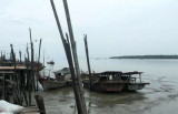
There are some fishing huts but few objects for identifying the low, mangrove covered coast. The mountain ranges inland are usually visible in clear weather.
Tanjung Siapiapi is a low welldefined point overgrown with mangroves of moderate height and is clearly visible up to a distance of 10 miles on SE and NW bearings. The mud bank S of the point extends about 2.2 miles offshore and is steep-to.
The Sungai Asahan is entered between Tanjung Napal, 10 miles SE of Tanjung Tambuntulang, and Tanjung Jumpul, about 2 miles to the SE. These points and the coast in the vicinity are low, muddy and overgrown with mangroves. The channel is marked by buoys and beacons. Jumpul ...
Tanjung Tambuntulang, about 11 miles ESE of Tanjung Tiram, is a low (3 m above sea level) overgrown point. The Sungai Tambuntulang discharges close W of the point and is marked by the village of the same name. Tambuntulang Bank, with depths of from 1.8 to 5.5m and fairly steep-to, ...
Between Tanjung Pertandangan and Tanjung Sinaboi, about 56 miles ESE, the only points of identification are the river mouths. The mangrove covered coast is mostly muddy and low lying. The coastal bank, as far out as the 10m curve, is marked by fishing stakes and enclosures. Fishing ...
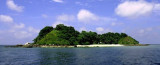
Pula Salahnama (3°20'N., 99°43'E.) is densely wooded;its rocky sides rise steeply from the sea. An above-water rocklies close N of the island and a similar rock lies about 0.5 mile S of the island. Anchorage can be taken about 1 mile from the NW and SE sides of Pulau Pandang ...
Between Tanjung Tanjung and Tanjung Tiram, about 9 miles SE, the coast is bordered by a white sandy beach except for a bank of mud and mangroves about 2 miles S of Tanjung Tanjung. A light is shown from Tanjung Tiram.
Pulau Pandang (3°25'N., 99°45'E.) is almost entirely surrounded by a coral reef with some above-water rocks. A foul area was reported to lie about 9 miles E of the island. A light is shown from Pulau Pandang.The island is hilly and covered with virgin
forest, nice for small ...


 The coast between Tanjung Jumpul and Tanjung Siapiapi, about 9 miles SE, is bordered by a mudbank with depths of less than 1.8m. This bank extends up to 5.75 miles off the former point and 2.5 miles off the latter point.