Localisation
Thunder Bay
| Latitude | Longitude |
| DMS | --- | --- |
| DM | --- | --- |
| DD | --- | --- |
Description

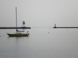
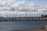
Harbor protected by a breakwater.
2011/04/20
Update
Anonymous

Port de commerce protégé par une digue.
2011/04/20
Update
Anonymous
Ebook | Great Lakes - Les Grands Lacs- 131 sites
- 11 photos
- publication date: 4 Aug 2024
- .pdf file size: 64 Mb
|
Share your comments or photos on "Thunder Bay"
Sites around Thunder Bay
Flying distances - Direct line