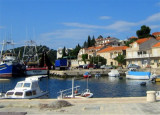
Uvala Vela Luka Korcula
6.1nm
300°
Easily identifiable by day or night, you can enter this great bay in all weather.
Dangers in the general approach are the ...
21 May 11
Jojo
| Latitude | Longitude | |
| DMS | --- | --- |
| DM | --- | --- |
| DD | --- | --- |


 Prizba is located on southern side of the island of Korcula, it is
overlooking to island of Lastovo and dozens of a small islets in front
of Prizba region.
Prizba is located on southern side of the island of Korcula, it is
overlooking to island of Lastovo and dozens of a small islets in front
of Prizba region.A small port is protected from winds from S and SE peninsula and surrounding islands.
Approach: From Rt Zaglav, to E, we move inside the chain of islands. U must just stay middle of the passage between the island and Korcula.
Beware Hrid Cerin SW of the peninsula, there are the bottom of each side of this rock, but the S of it, near O. Stupa, there are areas of shallow water at 6 m (NW) and 5 m (NE).
Coming from the SW, give a wide berth at the SE end of O. Kosor (shoal under 3.5 m of water).
Skip to the W Hrid Cerin.
We moored alongside at the deepest side or we anchor by 5 m S of the dock, but the holding is not safe.
Port open to winds from SW, S and SE.

 Prizba est située au S de Korcula, face à l'île de Lastovo et aux petits îlots qui se trouvent dans la région de Prizba.
Un petit port est protégé des vents du S et du SE par la péninsule qui l’entoure et par les îlots.
Approche: De Rt Zaglav, à l'E, on passe à l'intérieur de la chaîne d'îles. Il faut simplement rester u milieu du passage entre les îlots et Korcula.
Attention à Hrid Cerin au SW de la péninsule, il y a du fond de chaque côté de ce rocher, mais au S de celui-ci, près d'O. Stupa, il y a des zones de hauts-fonds sous 6 m d'eau (au NW) et 5 m (au NE).
En venant par le SW, donner un large tour à l'extrémité SE d'O. Kosor (haut-fond sous 3,5 m d'eau).
Passer à l'W d'Hrid Cerin.
On s'amarre au quai du côté le plus profond ou on mouille par 5 m au S du quai, mais la tenue n'est pas sûre.
Port ouvert aux vents de SW, S et SE.

Ebook | Dubrovačko-neretvanska županija (Dubrovnik–Neretva
|
Ebook | Dalmacija (Dalmatie)
|