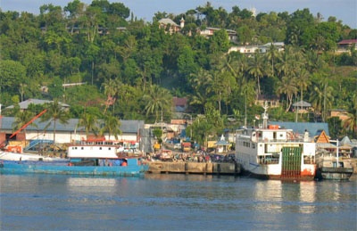
Gunung Sitoli harbour (E Nias)

Gunung Sitoli harbour (E Nias)

Para ubicar con precisión. Actualizar si es necesario.

Ubicación

Gunung Sitoli harbour (E Nias)
LatitudeLongitude
DMS------
DM------
DD------

Característica

Puerto

Descripción

Gunung Sitoli (Gunungsitoli is the capital and the port of Nias. It is located about 14 NM NW of Tg Lambaru and forms a deep bight.
At its head the hills approach the shore, leaving a strip of lowland between them.
6.29 The mouth of the river, leading to the port, will just admit small trading craft at HW; it is always marked by surf.
The port jetty lies N of the town. An oil jetty lies 7 miles SE. Pilots are not available.

Gunungsitoli, the chief town of the island, is the seat of government. It lies mainly on the left bank of the river.
The harbor is sheltered from W and SW winds, but to all winds from N and SE it is completely exposed so that considerable swells may result.
It is advisable to anchor, in 40m, mud, about 0.2 mile offshore.

The main jetty, 60m in length, is T-shaped at the head and has a depth of 12m alongside. An L-shaped town pier has a length of 67m and a depth of only 2m alongside. Gunungsitoli
Oil Jetty provides mooring to vessels up to 5,000 dwt with a maximum length of 90m. The berth lies at the head of a 170m long jetty with dolphins off each end. A depth of 9.5m is reported alongside.
2012/02/6
Actualizar
Jojo
Gunung Sitoli harbour (E Nias)
2012-02-06
Actualizar
Jojo
Ebook

Sumatra (Indonesia)

  • 326 sites
  • 109 photos
  • publication date: 23 Jul 2024
  • .pdf file size: 109 Mb
Comparta sus comentarios o fotos en "Gunung Sitoli harbour (E Nias)"

Sitios alrededor de Gunung Sitoli harbour (E Nias)

Flying distances - Direct line

Pulau Wunga (W Nias)

31nm
259°
Pulau Wunga, about 8 NM S of Pulau Mausi, is low andcovered with coconut trees.
A large conspicuous tree, visible for 16 miles, is located on a small elevationnear the N end.
The reef extending from the N side of the island is ordinarily marked by high rollers; on the S side ...
6 Feb 12
Jojo

Tanjung Mbaa (E Nias)

0.7nm
335°
North of Gunungsitoli, the coast is covered with coconut trees for about 6 miles.Close N of Gunungsitoli is Tanjung Mbaa, a rocky point from which a light is shown. From Tanjung Mbaa, a narrow strip of coast land extends about 3 miles NW, then a fringing reef leads up to Tanjung ...
6 Feb 12
Jojo

Tanjung Laaya (Laaja) (E Nias)

12nm
322°
Tanjung Laaja is the N end of the slope of a hill backing the coast. It is covered with coconut trees, steep-to, and free from dangers but is difficult to identify.
6 Feb 12
Jojo

Pulau Mausi (W Nias)

30nm
275°
Pulau Mausi, low and barren, lies in the S approach to Labuan Atjeh, about 2.2 miles SE of Tanjung Sosilutte.
It has a white sandy beach, and is fringed by a reef onwhich the sea always breaks, extending about 1 mile S; there is a depth of 7.7m at the outer end of the reef.
 An ...
6 Feb 12
Jojo

Pulau Sarangbaung (W Sumatra)

25nm
337°
Pulau Sarangbaung lies 10.5 miles NNE of the N extremity of Pulau Nias. There is a break in the reef on the SE side where boats can land at a village. The island is overgrown with coconuts and is visible for 12 miles.
4 Feb 12
Jojo

Tanjung Lambaru (E Nias)

14nm
130°
Tanjung Lambaru, located about 8 miles NW of Ujung Onolimbu, is swampy and thickly overgrown; dead trees stand on it and in the water close off it.At Tanjung Lambaru it has a width of 8 miles. The coast consists of a sandy beach, off which rocks are lying. The sea usually breaks, ...
6 Feb 12
Jojo