Kanal Nove Povljane Vir
20nm
292°
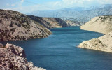
Des hauts-fonds à l'extrémité intérieure de ce canal restreignent le chenal à une largeur d'environ 250 m, avec une profondeur de 8m.
Les navires ayant ...
23 Jul 11
Jojo
| Latitude | Longitude | |
| DMS | --- | --- |
| DM | --- | --- |
| DD | --- | --- |

 Novigradsko More, est une baie enclavée, située à l'extrémité S de Novsko Zdrilo et offre un bon mouillage.
 Novigradsko More, a landlocked bay, lies at the S end of Novsko Zdrilo and provides good anchorage.
Luka Novigrad, a narrow inlet, lies at the S end of Novigradsko More. The small town of Novigrad stands along the shore and on the slopes of the hills at the E side of the head of the inlet and is fronted by a small craft harbor.
Karinsko Zdrilo, a narrow and tortuous channel, leads from the SE end of Novigradsko More into Karinsko More, a landlocked basin. This passage has depths of 11 to 20m in the fairway, but a sharp turn in the S part, with a width of only 90m, restricts its use to smallcraft and local coasters.
Ebook | Zadarska županija (Zadar county)
|