Bhimunipatnam (Andhra Pradesh-NE India)

Bhimunipatnam (Andhra Pradesh-NE India)

Pour géolocaliser ce lieu. Mettre à jour si besoin.

Localisation

Bhimunipatnam (Andhra Pradesh-NE India)
LatitudeLongitude
DMS------
DM------
DD------

Caractéristiques

Port
Boue
Mouillage
Sable

Description

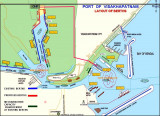
Bhimunipatnam lies on the S side of the mouth of the large and shallow Gostani River. Vessels anchor in the open roadstead off the town to work cargo.
The town is built on the E slopes of a hill, 166m high, which is topped by some trees and a pyramidal obelisk. A white temple lies about midway up the E slope of the hill and shows up well when the sun shines on it. A tall factory chimney lies about 2.5 miles NNW of the town, and is a good mark.
In the approach to the roadstead, the depths shoal gradually from the 18m curve about 2 to 3 miles offshore to a depth of 11m at the anchorage 1 mile offshore.

Two wharves lie on the S shore of the river but are available only to lighters. Cargo is carried to these wharves from vessels at the anchorage.

Weather signals are displayed from a flagstaff close SW of the lighthouse; the General System is used.

Anchorage can be taken, in depths of 11 to 12.8m, sand and mud, with good holding ground, about 1 mile offshore abreast of the town. During the Southwest Monsoon, a vessel should anchor with the lighthouse bearing 264°; during the Northeast Monsoon, anchorage should be taken with the lighthouse bearing between 249° and 259°.

The coast between Bhimunipatnam and Konada, about 10 miles to the NE, is sandy and broken about midway along its length by some low red cliffs which show up well when the sun shines on them.

2012/04/12
Mettre à jour
DeDe
Ebook

Bay of Bengal

  • 110 sites
  • 82 photos
  • publication date: 15 Jul 2024
  • .pdf file size: 55 Mb
Partagez vos remarques ou photos sur "Bhimunipatnam (Andhra Pradesh-NE India)"

Sites autour de Bhimunipatnam (Andhra Pradesh-NE India)

Flying distances - Direct line

Konada (Andhra Pradesh-NE India)

9.6nm
42°
Konada lies at the mouth of a small river. Several white buildings and some trees lie on the N side of the river.The coast between Konada and Kalingapatam, about 37 miles ENE, consists of a sandy beach backed by low sandhills.
14 Apr 12
DeDe

Visakhapatnam port (Andhra Pradesh-NE India)

14nm
213°
Vishakhapatnam, a port of growing importance and the fourth largest port in India, lies at the mouth of the Meghadri River, close NW of Dolphin’s Nose.
Petroleum and iron ore products are the principal exports.
The only shipyard in India capable of building ocean-going merchant ...
5 Apr 12
Jojo

Vizag military harbour (Andhra Pradesh-NE India)

15nm
223°
The city was so important during times of war that the Indian government decided to set up the Eastern Naval Command, overlooking the more populous Chennai and Kolkata, and developed Visakhapatnam during that period. 
The establishment of the E.N.C. soon after the construction ...
9 Apr 12
DeDe

Dolphin's Nose (Andhra Pradesh-NE India)

15nm
215°
Dolphin’s Nose, a bluff headland 163m high, is conspicuous when viewed from the NE or SW. A lighthouse with a racon, two radio masts, and a flagstaff stand on Dolphin’s Nose.Dolphin’s Nose has been reported to be a good radar target up to 17 miles.Caution: A wreck lies about ...
5 Apr 12
Jojo

Santhapalli rocks (Andhra Pradesh-NE India)

17nm
66°
Santapelli rocks, with a least depth of 1.5m and dangerous wrecks close E, lie between 5.5 and 6 miles SE of Santapilli Light. The sea breaks heavily over these dangers with a moderate swell, but not in good weather.
The channel between these rocks and the mainland is safe only ...
15 Apr 12
Jojo