| Latitude | Longitude | |
| DMS | --- | --- |
| DM | --- | --- |
| DD | --- | --- |


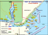
 Bhimunipatnam lies on the S side of the mouth of the large and shallow Gostani River. Vessels anchor in the open roadstead off the town to work cargo.
Two wharves lie on the S shore of the river but are available only to lighters. Cargo is carried to these wharves from vessels at the anchorage.
Weather signals are displayed from a flagstaff close SW of the lighthouse; the General System is used.
Anchorage can be taken, in depths of 11 to 12.8m, sand and mud, with good holding ground, about 1 mile offshore abreast of the town. During the Southwest Monsoon, a vessel should anchor with the lighthouse bearing 264°; during the Northeast Monsoon, anchorage should be taken with the lighthouse bearing between 249° and 259°.
The coast between Bhimunipatnam and Konada, about 10 miles to the NE, is sandy and broken about midway along its length by some low red cliffs which show up well when the sun shines on them.
Ebook | Bay of Bengal
|


