
| Latitude | Longitude | |
| DMS | --- | --- |
| DM | --- | --- |
| DD | --- | --- |
 channel 12, 16


Ebook | Bay of Bengal
|
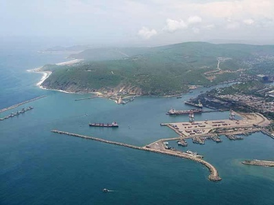
 Vishakhapatnam, a port of growing importance and the fourth largest port in India, lies at the mouth of the Meghadri River, close NW of Dolphin’s Nose.
The only shipyard in India capable of building ocean-going merchant vessels is in operation within the harbor area. Ample berthing facilities are available to accommodate all classes of vessels.
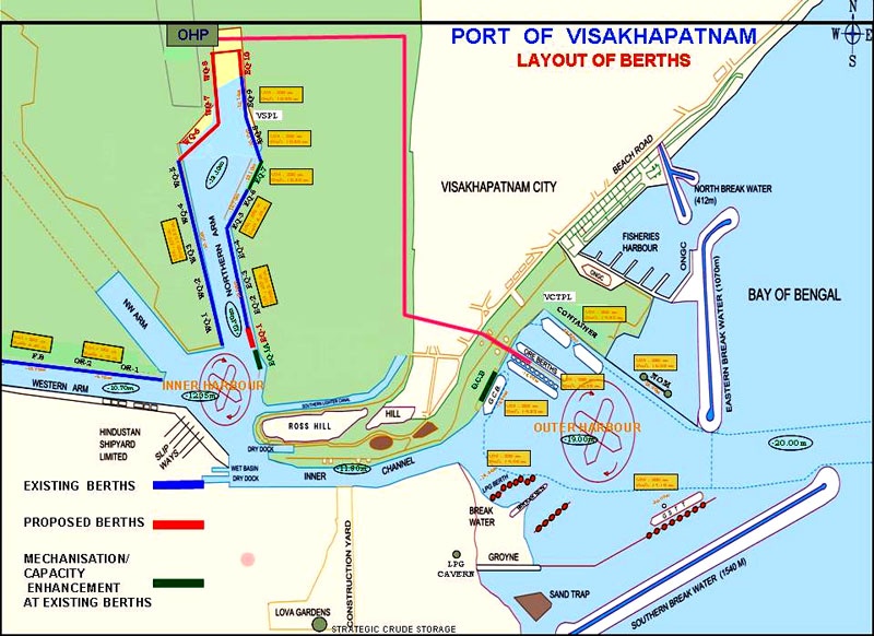
The Port has three harbours viz., outer harbour, inner harbour and the fishing harbour.
Vishakhapatnam Fishing Harbor is separated from Outer Harbor by Groyne No. 2 which connects to East Breakwater and it is entered between N end of the East Breakwater and North Breakwaters. A light shows at the end of the North Breakwater. Several jetties extend NE from Groyne No. 2 with a depth of 4.5m alongside the quayage.
Southwest winds prevail from March to August; NE winds prevail from October to December. During the day, the NE winds are fresh, but at night they are light and westerly. Heavy, windy, rain squalls occur during October and November, but most of the rainfall occurs from June through November.
A considerable swell is experienced almost all year in the vicinity of the port. Vessels have remained in the harbor with safety during cyclonic weather.
The climate is subtropical and varies from warm to hot, with high humidity throughout the year. Maximum temperatures occur in May, while minimum temperatures are usually recorded in December and January. Through May, June, and July, temperatures often exceed 38°C.
From about August to November, the current sets SW; from about the middle of December through June, it sets NE. Inside the 35m curve, the current is much weaker than farther offshore. Close offshore tidal currents will sometimes be experienced.
In the seaward approach to the harbor, a depth of 18.2m exists about 0.4 mile E of the head of South Breakwater.
The outer entrance channel between the outer breakwaters is 183m wide and maintained to a depth of 19m prior to the entrance and to a depth of 18m beginning just inside the breakwaters, as best seen on the chart. In 2007, it was reported that vessels up to 225m long, with a maximum beam of 32.5m and a maximum draft of 9.25m could be accommodated in the Inner Harbor and only daytime navigation was allowed.
The ore berth, in the outer harbor, is dredged to a depth of 17.5m on its NE side and 17.5m on its SE side, and can accommodate two bulk carriers of 150,000 dwt. It has been reported that draft on the SW side of the ore berth was restricted to 15.3m. The entrance to the inner harbor isn dredged to 18m.
A general cargo berth, 270m long, with a dredged depth of 15.2m alongside, can accommodate vessels up to 232m long and 14.5m draft, and is located SW of the ore berth; facilities at the berth include a conveyor system for the importation of coking coal. It has been reported (1996) that during the Northeast Monsoon, the berth may be subject to considerable swell and vessels may have to be moved.
A container berth located NE of the ore berths has a dredged depth of 11.0m alongside. The terminal is 449m long and can accommodate vessels with a maximum draft of 14.9m.
A turning circle, maintained to a depth of 19m, lies between the ore berth and the inner end of the outer entrance channel.
The entrance channel to the inner harbor is dredged to a depth of 10.7m.
A turning basin, dredged to 11.6m, lies at the N end of the entrance channel to the inner harbor. The three basins which project from the turning basin are all dredged to 10.7m.
East Quay Berths lie on the E side of Northern Arm. Berth Q1 to Berth Q5, with a total berthing length of 905m and alongside depths of 10.0m, can accommodate vessels with a maximum draft of 10.06m. Berth Q6 and Berth Q7, with a total berthing length of 350m and alongside depths of 10.4m, can accommodate vessels with a maximum draft of 10.21m.
West Quay Berths lie on the W side of Northern Arm. Berth J1 (Berth Q1), with a berthing length of 160m and an alongside depth of 9.5m, can accommodate vessels with a maximum draft of 10.06m. Berth Q2 and Berth Q3, with a berthing length of 428m and an alongside depth of 10.7m, can accommodate vessels with a maximum draft of 10.06m. Berth Q4 and Berth Q5, with a berthing length of 440m and an alongside depth of 10.7m, can accommodate vessels with a maximum draft of 10.21m.
East Quay No. 8, a new multi-purpose berth, can accommodate vessels up to 180m long, with a beam of 32m and a draft of 10m on a rising tide. Further details can be obtained from the port authority.
There is a shipbuilding yard SW of the inner harbor turning basin; a fitting-out wharf lies on the S side of the W arm.
On the N side of Western Arm are two oil berths, with a total berthing length of 365m and alongside depths of 9.8m, which are connected by pipeline to the oil refinery and can accommodate vessels with a maximum draft of 10.06m at Berth 1 and 9.75m at Berth 2. A fertilizer wharf close W of the oil berths, with a length of 167m an alongside depth of 10.7m, can accommodate vessels with a maximum length to 168m and maximum draft of 10.06m. Vessels whose length exceeds 171m or whose draft exceeds 9.1m, may only enter the harbor at HW between the hours of 0600 and 1800. Smaller vessels may enter at any time.
The mooring berths, which lie adjacent to the turning basin, have depths of 10.7m alongside the buoys. T.T. Up Jetty (M1 Berth), between the mooring buoys, lies close E of the turning basin. It is 213m long and can accommodate a maximum draft of 10.06m 6.28 A berth for discharging oil, with an alongside depth of 19m, is located close NW of South Breakwater. Tankers of 260m length and 14.3m draft can be accepted. A submarine oil pipeline is laid from the berth, W to a trestle bridge, and then leads to the coast.
A new offshore oil berth has been added to accommodate tankers up to 150,000 dwt, 280m in length, and with a draft of 17m.
Pilotage is compulsory for power-driven and ocean-going vessels over 100 grt who wish to enter, depart, or shift berth within the harbor area. Pilots board 1.3 miles SE of South Breakwater Light.
Vessels should send their ETA 48 hours and 24 hours in advance. Vessels planning to enter the harbor on the same day of arrival should arrive off the entrance prior to 2100.
Local port regulations:
1. Only one vessel may enter or leave the harbor at a time.
2. Tugs are maintained to assist vessels, as necessary, in entering the harbor or shifting berths.
3. A pilot is required to be on board a vessel whenever a tug is employed.
4. Sailing vessels of 100 grt or greater shall not enter or leave the harbor unless towed by one or more tugs.
5. No ballast may be thrown or discharged overboard within the harbor limits.
Signal Station No. 1, with a flagstaff 26m high, lies midway on the East Breakwater about 1 mile E of Ross Hill.
Signal Station No. 2 (Dufferin Signal Station), with a flagstaff, lies on the W side of Ross Hill, close E of another flagstaff, 68m high.
Sand Hill Signal Station lies about 1.8 miles NNE of the Dolphin’s Nose Light.
These stations communicate visually with vessels approaching or departing the harbor.
The following signals are displayed for the use of entering and departing vessels:
These stations communicate visually with vessels approaching or departing the harbor.
The following signals are displayed for the use of entering and departing vessels:
1. Signal Station No. 1, upon sighting a vessel approaching the port, displays the International Code Flag P until the pilot answers by the entering signal
2. Vessels entering the harbor must display International Code Pennant 4 and enter only after Signal Station No. 1 has repeated the signal hoist. A green metal pennant with a white circle hoisted at Signal Station No. 1 and Signal Station No. 2 indicates the channel is clear for shipping.
3. A vessel waiting to enter the harbor should, if International Code Pennant 1 is displayed at Signal Station No.1, keep well clear of the entrance to allow the departing vessel plenty of room.
4. Vessels about to leave should display International
Code Pennant 1 and proceed only after Signal Station No. 2 has repeated the signal hoist.
5. A vessel entering or departing at night and requiring a pilot displays a white light over a red light where it can best be seen by the signal stations.
Storm and weather signals are displayed; the General System is used.
The port can be contacted, as follows:
1. Call sign: Vizag Port or Vizag Control
2. VHF: channels 12 and 16
3. Tel: 91-891-2564841
4. Fax: 91-891-2565023
5.Mail: info@vizagport.com
Vessels awaiting to enter the harbor should anchor, in a depth of 22m, about 1.5 miles E of Dolphin’s Nose Light.
Because of the currents and shoaling on the N side of the entrance channel, vessels should not approach inshore of the anchorage without a pilot.
Vessels anchoring in the roadstead must leave sufficient room for vessels entering or departing. Anchors should be buoyed.
Anchorage is prohibited in an area at the inner end of the entrance channel, as shown on the chart.
An Examination Anchorage Area is enclosed by a line as shown on the chart.
Anchorages for petroleum tankers are situated 1.5 and 3 miles SE of Dolphin’s Nose Light. A gas and explosives anchorage lies 3.5 miles SSE of the light.
It has been reported (1996) that during the Northeast Monsoon, vessels at anchor lie to the current, bow NE, regardless of wind and swell.
Vessels approaching the harbor should pass through a position about 7 miles bearing 135° from Sand Hill Light, then steer 315° until a depth of 18.3m is sounded.
Course should then be altered to bring the lighted entrance beacons in line bearing 280°, which lead through the entrance channel between the breakwater heads and into the harbor. The alignment of the various channel reaches leading into the inner harbor are well defined by lighted range beacons.
The coast between Vishakhapatnam and Bhimunipatnam, about 16 miles NNE, continues hilly.
Caution.—There have been a number of pirate attacks on merchant vessels in this area. Mariners are advised to keep a sharp lookout, especially at night, for pirates attempting to board their vessel.


