Otok Miljet

Otok Miljet

To precisely geolocate this site. Update if necessary.

Localisation

Characteristics

Island / Atoll
Natural Park

Description

Stretched over a forty kilometers from Dubrovnik and Korcula, the island of Mljet blossomed into a beautiful protected natural park.
National Park Mljet National Park was proclaimed in 1960 and covers the western part of the island of Mljet. The main grounds for declaring the island National Park are the rugged coastline and lush forest. In the southern part of the island, the sea flows into the island by creating small canyon Veliko jezero, Grand Lake and after a narrow canyon made ​​Malo jezero, Le Petit Lac. However they are salt lakes, these lakes are rich in real lakes varied shellfish (mussels, marine pinner, arches and oysters) and the plankton of these lakes was the subject of numerous scientific works.
In the southern part of Grand Lake is located on the island of Sainte-Marie, with the old Benedictine monastery and a church dating from the 12th century. Today the monastery is the construction of the Renaissance is surrounded by a courtyard. At the southeast corner of the island is built around the defense. All buildings on the island, the church included, protect the islet. Today the monastery is a restaurant.
Vegetation on the island, especially that of the national park is very lush and this vegetation, this island is nicknamed "the green island".
The side S should not be approached too closely and has no good anchorages.
The port and main anchor of Mljet is luka Polace on the NW coast, a ferry port.
2011/05/5
Update
Jojo
Etirée sur une quarantaine de kilomètres entre Dubrovnik et Korcula, l’île de Mljet s’épanouit en un magnifique parc naturel protégé.

Le Parc national de Mljet est proclamé le Parc national en 1960 et couvre la partie de l’ouest de l’île de Mljet. Les motifs principaux pour proclamer cette île le Parc national sont la côte découpée et la végétation luxuriante des forêts. De la partie du sud de l’île, la mer se jette dans l’île par le petit canyon en créant Veliko jezero, Le Grand Lac et après par un canyon plus étroit fait Malo jezero, Le Petit Lac. Cependant ce sont des lacs salés, ces lacs sont des vrais lacs riches en coquillages variés (moules, pinnes marines, arches et huîtres) et le plancton de ces lacs fut l’objet de nombreux œuvres scientifiques.

Dans la partie du sud du Grand Lac est située l’îlot de Sainte-Marie, avec le vieux monastère bénédictin et une église datant du 12e siècle. Aujourd’hui le monastère est la construction de la Renaissance qui est entourée d’une cour. Au coin sud-est de l’îlot est construite la tour de défense. Toutes les constructions sur l’îlot, l’église incluse, protègent l’îlot. Aujourd’hui dans le monastère vous trouverez un restaurant.

La végétation sur l’île, surtout celle du Parc national est très luxuriante et pour cette végétation, cette île est surnommée “l’île verte“.

La côte S ne doit pas être approchée de trop près et n'a pas de bons mouillages.
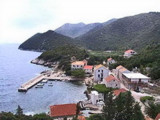
Le port et mouillage principal de Mljet est luka Polace, sur la côte NW, qui est un port de Ferry.

2011/05/5
Update
Jojo
Ebook

Dubrovačko-neretvanska županija (Dubrovnik–Neretva

  • 140 sites
  • 228 photos
  • publication date: 6 Aug 2024
  • .pdf file size: 79 Mb
Ebook

Dalmacija (Dalmatie)

  • 568 sites
  • 963 photos
  • publication date: 5 Aug 2024
  • .pdf file size: 350 Mb
Share your comments or photos on "Otok Miljet"

Sites around Otok Miljet

Flying distances - Direct line

Otok Sipan

15nm
93°
It is the largest and most populated island of the group Elafiten. It rises to 234 m at its N and a prominent hill rises 224 m NW of the SE end.
Ruda is a small island that is 0.5 M SE of the NE extremity of the island and Misnjaka, 13 m high, lies close off the NW extremity.
...
16 Apr 11
Jojo

Stonski Kanal

9.7nm
66°
Stonski Kanal, a deep inlet, indents the SE end of Poluotok Peljesac at the NW end of Kolocepski Kanal.
Its shore rises rapidly on each side and provides protection from NE and SW winds. The village of Brocej is situated on the S shore 3.8 miles within the entrance.
It is fronted ...
25 Apr 11
Jojo

Zaliv Klek Neum

11nm
10°
The narrow sea from Zaliv Klek Neum is 4 NM long and lies at the NE channel Malog Stone. It is surrounded by mountains and is inserted between Rt Rep Kleka and Rt Meded.
Depths exceeding 20 meters in most cases. There are several anchorages.
The SE part and W peninsula ...
3 May 11
Jojo

Luka Sobra Mljet

2.8nm
95°
Sobra Luka is the port of Babino Polje, the main village of Mljet. There is a large open bay to the NE.
Much of the bay is shallow or rocky, you can not anchor in the bay. We can tie the little dock that is located in the SW corner of the bay or wharf near the ferry pier.
O. ...
8 May 11
Jojo

Sobra

2.9nm
95°
24 Apr 25
Anonymous

Luka Kozarica Miljet

3.7nm
302°
Kozarica is one of the oldest settlements on the island which is located at the foot hills of the Great and Small town (big city-the highest peak on the island).There is a small port, unfrequented by boaters, located 1.4 NM ESE Hrid Kula (at the entrance of luka Polace). There is ...
8 May 11
Jojo