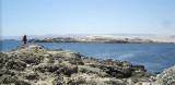
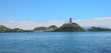
Bahia de Copiapo (Atacama N Chile)
17nm
200°
Copiapo was once a shipping ore port, but it is no longer used such as such because of the poor anchorage and landing ...
9 Jan 13
Joëlle
| Latitude | Longitude | |
| DMS | --- | --- |
| DM | --- | --- |
| DD | --- | --- |


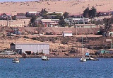
 Punta Caleta quay is 300 m NW of Punta Caleta. It is used for loading or discharging fruit, iron ore, and general cargo.
Muelle Fiscale, 1,5 NM SE of the Punta Caldera ligh, is a quay used for loading fishmeal from lighters and small craft berthing with a maximum draft of 5,3 m.
At 0,6 NM E Punta Caldera, at Punta Padrones, is a wharf reserved for copper.
")
 Le quai de Punta Caleta se trouve à 300 m au NW de punta Caleta. Il est utilisé pour charger ou décharger des fruits, du minerai de fer et des marchandises générales.
Muelle Fiscale, à 1,5 MN au SE du phare de Punta Caldera, est un quai utilisé pour le chargement de la nourriture pour poisson et l'accostage de petites embarcations avec un TE maximum de 5,3 m.
A 0,6 MN à l'E de Punta Caldera, à Punta Padrones, se trouve un quai réservé aux chargements du cuivre.
") Puerto Padrones
Puerto Padrones") Muelle Punta Caleta
Muelle Punta Caleta")
Ebook | Chile
|