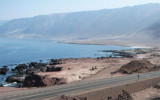

Punta Algodonales (Antofagasta N Chile)
0.3nm
254°
18 Dec 12
Joëlle
| Latitude | Longitude | |
| DMS | --- | --- |
| DM | --- | --- |
| DD | --- | --- |
 9, 14, 16
 Tocopilla is a port city that was founded in 1843 by the French Dominique Latrille Loustauneau. He installed a small copper smelter. It also was operated the guano and copper. In 1877 he drew the plans of the village on behalf of the Bolivian authorities.
Tocopilla is S Algodonales Bay. It is an important port that also has nitrates fishmeal, bulk coal, containers and petroleum products being shipped.
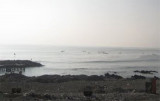
The port is well-protected from the prevailing S and SW winds, but it is exposed to strong N and NW winds during the winter months. Frequent fogs occur from June to September. When fogs are low, it is impossible to determine accurately a vessel’s position offshore and caution must be exercised when calling at the port.
There is a condition known as the ‘Surf’ that occurs between May and September. The Surf is a heavy swell condition that can cause a reduction in productivity and in some extreme cases a complete stoppage of cargo operations and require the need for vessels to change berths.
Tel: 56 55 813279
Fax: 56 55 813279
Mail: cptocopilla@directemar.cl
")
 Tocopilla est une ville portuaire qui fut fondée en 1843 par le Français Dominique Latrille Loustauneau. Celui-ci y installa une petite fonderie de cuivre. On y exploita aussi le guano et le cuivre. En 1877 il traça les plans du village pour le compte des autorités boliviennes.
Tocopilla se trouve au S de la baie Algodonales. C'est un important port de nitrates qui expédie aussi des farines de poisson, du charbon en vrac, des containers et des produits pétroliers.
Le port est bien protégé des vents du S et SW, mais il est exposé aux forts vents du N et NW pendant les mois d'hiver.
Des brouillards fréquents ont lieu de Juin à Septembre.
Une "houle" survient entre Mai et Septembre et peut entraîner une réduction de la productivité et quelquefois même un stoppage complet des activités des cargos.
Tel: 56 55 813279
Fax: 56 55 813279
Mail: cptocopilla@directemar.cl
")
")
Ebook | Chile
|