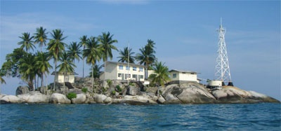
Pulau Kepulauan Singkeplaut (SE Pulau Singkeplaut)
A conspicuous tree is reported to stand on Pulau Singkeplaut.
| Latitude | Longitude | |
| DMS | --- | --- |
| DM | --- | --- |
| DD | --- | --- |


Ebook | Sumatra (Indonesia)
|
 Pulau Berhala is a rocky island largely covered with high trees. Two bare peaks, each 91m high, rise on the W side of the island; the island is inhabited. It lies in the middle of Selat Berhala, nearly between Tanjung Jabung and Tanjung Buku, the SW end of Pulau Singkep. Except on the W side, the island is surrounded by a reef which dries at LW, and extends for a distance of 0.2 mile from the E side.
A light is shown from Pulau Berhala.
The channel N of pulau Berhala to Pulau Pulau Singkeplaut, 10 NM NE, is not recommended; it is not safe, on account of uncharted dangers that probably exist and the rocks in it. Pulau Berhala Light, which is situated on the S side of the island, is not visible throughout the channel transit.
A stranded wreck lies on a previously uncharted pinnacle of rock approximately 3.5 miles NE of Pulau Berhala Light.
Several dangerous wrecks, best seen on the chart, lie NE of Tanjung Jabung and SW of Pulau Berhala. A reef, numerous rocks, islets, and depths under 9.1m surround Pulau Berhala. An 8.7m patch lies 2 miles SE of Pulau Berhala; a 5.5m shoal lies 1.25 miles NW of the same island.
A 9.6m shoal lies 5.5 miles SE of the light shown on the southernmost islet S of Pulau Berhala.


