Access to the Bay Tiha coming from S, is passing midway between O. Mrkan and the mainland, leaving Plicina Seka Velika starboard before turning NE. Pass midway between the cape and the S of rock discovered in Supetar. From the N, go to E O. Supetar avoiding the rock and the shoal SE O. Supetar. Tiha Bay is bordered by large hotels. We can dock at the quay by 2 to 3 m or anchor by 4 m or more away from moorings.
2011/04/14
Update
Jojo
2011-04-14
Update
Jojo
L'accès à la baie de Tiha en venant du S, se fait en passant à mi-chemin entre O. Mrkan et le continent, laisser Plicina Seka Velika sur tribord avant de virer au NE. Passer à mi-chemin entre le cap et le rocher découvert au S de Supetar. En venant du N, passer à l'E d'O. Supetar en évitant le rocher et le haut-fond au SE d'O. Supetar.
La baie de Tiha est bordée par de grands hôtels.
On peut accoster au quai par 2 à 3 m ou mouiller par 4 m ou plus à l'écart des corps-morts.
It is the largest and most populated island of the group Elafiten. It rises to 234 m at its N and a prominent hill rises 224 m NW of the SE end. Ruda is a small island that is 0.5 M SE of the NE extremity of the island and Misnjaka, 13 m high, lies close off the NW extremity. ...
Zupski Zaliv is entered between Rt Sustjepan and Rt Pelegrin, 2.5 miles NW. The E and SE shores of this bay are backed by mountains, but a valley through which a river flows lies within the N shore. Malastica, 628m high, stands 1 mile N of the bay. This hill has a somewhat sharp ...
The middle bay of Boka Kotorska, is connected to Topaljski Zaliv by Kumborski Strait, a deep passage. This bay is steep and rocky on its S side, but the NE and NW shores, which are backed by mountains, are low and cultivated. Uvala Kukuljina and UvalaKrtole, separated from each ...
Otocic Cavtatski Grebeni, a group of islets and above-water rocks, lies up to 2 miles W of Rt Sustjepan, on a line NW-SE parallel to the coast. Otocic Mrkan, the largest islet, is 65m high and appears dark from seaward. NW is the island Bobara. Between the two islands are ...
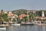
The small town of Cavtat is located 19 km southeast of Dubrovnik. It is built on the peninsula of Rat (or peninsula St Roch) between two bays: Uvala Luka which separates the peninsula Sustjepan and uvala Tiha NE. Both bays are facing the island Supetar.Approaching Cavtat by the ...
Rt Sustjepan (42°35'N., 18°13'E.), 49m high, is the NW extremity of a narrow projection which extends 1 mile NW from the coast.Rt Rat is the NW extremity of a similar projection, 42m high, located 0.3 mile NE. Cavtatska Luka, an inlet, is entered between these points; the town of ...


 Access to the Bay Tiha coming from S, is passing midway between O. Mrkan and the mainland, leaving Plicina Seka Velika starboard before turning NE. Pass midway between the cape and the S of rock discovered in Supetar.
 L'accès à la baie de Tiha en venant du S, se fait en passant à mi-chemin entre O. Mrkan et le continent, laisser Plicina Seka Velika sur tribord avant de virer au NE. Passer à mi-chemin entre le cap et le rocher découvert au S de Supetar.