St George's Islands (W India)
7.1nm
186°
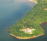
Grandi Island is the collective name of the two S islands of the group, which are connected by a narrow reef of rock and shingle.
The W of the two islands, 76m high and conical, is ...
4 Mar 12
Jojo
| Latitude | Longitude | |
| DMS | --- | --- |
| DM | --- | --- |
| DD | --- | --- |


 Aguada Bay, entered between Aguada and Kabo Rajniwas, about 1.8 miles SSE, affords anchorage to moderate-sized vessels during the Northeast Monsoon.
The bay is free from dangers, but strong W winds produce a heavy swell.
Panaji, the capital and seat of government of the State of Goa, Daman, and Diu, is situated on the S bank of the Mandavi River, which enters the head of the bay. The city is well built, with prominent buildings along the waterfront.
A bridge spans the river at the E end of the city.
The tidal rise at Panaji is 2.3m at MHWS and 2.06m at MHWN.
The ebb current sets strongly out of the Mandavi River, but is weak at the anchorage off Aguada, where the flood current is barely perceptible.
Depths in the entrance of Aguada Bay are about 7.6m, decreasing gradually to the head of the bay.
Outer Patches, with a least depth of 0.9m, lies about 0.8 mile W of Kabo Rajniwas.
The bar of the Mandavi River, which is subject to frequent change, has a depth of 2.1m during good weather. During the Southwest Monsoon, heavy breakers extend across the entrance and render it impassable.
The main channel, less than 183m wide, lies between sand banks extending about 0.9 mile SW of Raij Magus, the N entrance point of the river, and about 0.5 mile SW from Gaspar Dias, the S entrance point of the river. Raij Magus Light is shown from mid-August to mid-June from a white round tower 0.3 mile NNE of Raij Magus Point.
Raij Sand, which dries, lies in the fairway W of Panaji.
The dangers in the channel are not marked.
Most cargo is worked from anchorage.
The port has a jetty, 92m long, with an alongside depth of 4.3m. There is a pier for inspections and surveys of barges and small craft up to 75m in length and a beam of 15m can be accommodated.
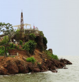
Aguada Light is shown from a white rectangular tower close N of the fort; a tower lies close SE in the N part of the fort. A racon is situated at the light. Another light is shown about 183m S of the tower.
A chapel, with an elevation of 74m, stands about 0.5 mile E of Aguada Fort Light.
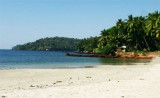
The coast close N of Aguada is low and a heavy surf always runs along the foreshore.
Pilotage is compulsory in the Mandivi River as well as for vessels proceeding to the inland portions of the Mandavi River and the Zuvari River. Local pilots may be engaged by contacting the Captain of the Port, Panaji.
The vessel’s ETA should be sent to the Port Captain 4 days, 3 days, 48 hours, and 24 hours prior to arrival.
Panaji is a fair weather anchorage port making any cargo operations worked from anchorages impossible during the Summer Monsoon period (about May 15 through September 15).
The port can be contacted, as follows:
1. VHF: VHF channels 16 and 74
2. Telephone: 91-832-2225070
91-832-2420580
91-832-2420579
3. Facsimile: 91-832-2420582
91-832-2421483
4. E-mail: captainofports@eth.net
The Port Captain can be contacted via mobile telephone at 91-9225-905926 and 91-9890-331573.
Hours of operation are 0930 to 1745 local time.
During good weather large vessels can anchorabout 14m, mud, about 2 miles W of Aguada.
Vessels of moderate size can anchor, in 6.4m, mud, with Aguada Fort Light bearing 333°, distant 1 mile.
Vessels approaching from the N should give the W extremity of Aguada a berth of at least 1 mile. A dangerous wreck lies in about 4.5 miles NW of Mormagao Head.
Vessels approaching from the S should take care to avoid the dangers in the entrance to Marmagao Bay and the foul ground extending W from Cabo Point.
") Aguada fort and lighthouse
Aguada fort and lighthouseEbook | Arabian Sea
|