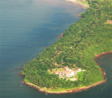
Marmagao Head, about 61m high, is a tableland peninsula with steep sides, especially W. It is connected to the mainland SE by a narrow neck of low ground.
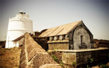
A conspicuous water tower, with an elevation of 74m, is situated about 0.5 mile SE of Marmagao Point. North Head Breakwater Light is shown from a white concrete tower at the N point of the breakwater.
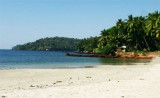
St George’s Islands consists of three islands between 1.5 and 2.5 miles SSW of Marmagao Head. Grandi Island is the collective name of the two S islands of the group, which are connected by a narrow reef of rock and shingle. The W of the two islands, 76m high and conical, is ...
Marmagao (or Mormugao) port is located in marmagao bay that is entered between Marmagao Head and Kabo Point. The entrance to the bay is encumbered with shoals. The Grandi Islands lie in the S approach to the bay.The S side of Marmagao Bay is bold and rocky, rising to the tableland ...
Cabo point, at the W extremity of the island of Goa, is a prominent headland, 55m high. A conspicuous church spire is situated near the seaward end of the headland.
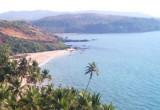
Aguada Bay, entered between Aguada and Kabo Rajniwas, about 1.8 miles SSE, affords anchorage to moderate-sized vessels during the Northeast Monsoon. The bay is free from dangers, but strong W winds produce a heavy swell.Panaji, the capital and seat of government of the State of ...
The coast between Cola Bay and the Sal River, about 14 miles SSE, consists of low cultivated land with several churches on small hills. Anchorage, sheltered from NW winds, can be taken, in a depth of about 7m, in Cola Bay.
Canaguinim Bay is entered between Canaguinim Point, about 1 mile SW of Betul Point, and Moliem Point, about 2 miles SW. Two rock patches, each drying 1.2m, lie about 0.1mile and 0.3 mile, respectively, SW of Canaguinim Point. Cliffs, about 38m high, lie on the E half of ...


 Marmagao Head, about 61m high, is a tableland peninsula with steep sides, especially W. It is connected to the mainland SE by a narrow neck of low ground.
")