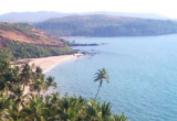
St George's Islands (W India)
3.2nm
193°
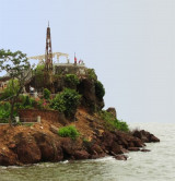
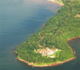
Grandi Island is the collective name of the two S islands of the group, which are connected by a narrow reef of rock and shingle.
The W of the two islands, 76m high and conical, is ...
4 Mar 12
Jojo
| Latitude | Longitude | |
| DMS | --- | --- |
| DM | --- | --- |
| DD | --- | --- |
 channel 16

 Marmagao (or Mormugao) port is located in marmagao bay that is entered between Marmagao Head and Kabo Point.
The S side of Marmagao Bay is bold and rocky, rising to the tableland of Marmagao Head.
The N shore of the bay between Kabo Point and Nazaret Point, about 4.5 miles ESE, consists of alternating stretches of sand and rock. The land within is covered with jungle and rises to an elevation of 45m.
A radio mast, with an elevation of 175m, is conspicuous about 2 miles NNW of Nazaret Point.
Marmagao is one of the oldest ports on the west coast of India, protected by a breakwater as well as a mole constructed E of the seaward end of the breakwater. The port lies on the N side by Marmagao Head. It is the leader in exporting iron ore in India as well as manganese ore and alumina. Imports include petroleum products, chemicals, other general cargo and a growing container trade.
Occasional strong NE winds from about the middle of February to the end of March cause a heavy swell in Marmagao Bay. These winds usually last from 3 days to a week and decrease in strength from sunset to sunrise.
However, it has been cautioned by the local authorities that the weather deteriorates without warning.
The tidal rise at Marmagao is 2.3m at MHWS and 1.6m at MHWN.
Tidal currents in the outer anchorage off Marmagao Bay are weak.
The port is approached through a dredged channel entered between Lighted Buoy No. 1 and Lighted Buoy No. 2, moored 2 miles W of of Marmagao Point.
The channel, which leads to the inner anchorage and the berthing area, is about 4.6 miles long and 250m wide. The channel has been dredged to a depth of 14.4m although lesser depths have been reported (2002).
Vessels up to 70,000 dwt, with a maximum draft of 12m, can berth alongside. Vessels up to 275,000 dwt can be accommodated in midstream.
The port authority applies an underkeel clearance of 1.2m and a swell allowance of 0.5m. During the Southwest Monsoon period a higher swell allowance is used.
A quay extends 1.5 miles E and SE from the root of the breakwater and affords ten numbered berths, including berths for tankers and ore carriers at its SE end.
Limitations at these berths are given in the accompanying table titled Marmagao Bay—Berth Limitations.
Draft limitations for the above berths are subject to frequent change in conjunction with the state of tide, underkeel clearance, prevailing sea, and weather conditions. Details of changes can be obtained from the local pilot or the Port Officer.
Night navigation is permitted only during the fair season (mid-September to the end of May), but there are still restrictions placed on vessels working at Berths 9, 10, and 11. Detailed information should be obtained from the Harbor Master if this is applicable.
A floating dock extends NE from Berth:
No. 1. A breakwater extends NE from between Berth No. 2 and Berth No. 3.
Vessels requiring to top-off to their seasonal mark may be permitted W of the breakwater during fair weather season.
Several mooring buoys are situated E and SE of the head of the mole. Five finger piers for small vessels and barges lie within 0.2 mile SE of the Berth No. 9.
Foul ground borders Grandi Island up to 0.3 mile offshore. A 5m patch lies about 0.5 mile NE of the E end of the island; other patches, with depths of 3.9m, lie 0.7 mile N and 0.6 mile NNW of the same position.
Saint Georges Reef, which dries 1.5m, lies about 0.3 mile E of Grandi Island.
Sail Rock, 14m high, lies about 0.5 mile S of the W end of Grandi Island; this pillar rock can easily be mistaken for a sail.
A reef, which dries 1.2m, lies about 0.2 mile NE of Sail Rock.
Saint George’s Bank, with a least depth of 6.5m, lies about 0.8 mile WNW of Grandi Island.
Martha Patches, a group of rocky shoals with a least known depth of 2.7m, lie about 1 mile N of Grandi Island.
Marmagao Rocks, with a least depth of 6.1m, lie about 0.5 mile N of Marmagao Point, and are marked on their S side by Lighted Channel Buoy No. 6.
An 8.2m patch and a 7.9m patch lie about 0.5 mile NNW and 1.3 miles W of Marmagao Point.
Amee Shoals, close N of Marmagao Rocks and lying in the middle of the entrance to Marmagao Bay, is a group of shoals with a least depth of 1.8m.
Sunchi Reefs, about 1 mile S of Kabo Rajniwas, are rocky shoals, one of which dries 0.9m. Marivel Patches, with a least depth of 0.4m, lie close NE.
Kambariam Islet (Buffalo Rock), 6m high, lies about 1 mile SW of Marmagao Point, the NW extremity of Marmagao Head. Foul ground extends about 0.2 mile N of the islet.
Sawyer Patches, with depths of 4.9m, lie about 0.5 mile N of Kambariam Islet.
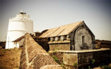
A mole extends E about 0.1 mile from E side of the breakwater; Breakwater East Head Light is shown from a squat masonry tower at the head of the mole.
Tel: +91 832 2521100
+91 832 2521200
Fax:+91 832 2521105
Mail: mptgoa@mptgoa.com
Pilotage is compulsory. Vessels should send, via their agent, a request for pilotage, at least 48 hours in advance.
Vessels awaiting a pilot may anchor, in about 13m, mud, about 2 miles WNW of Marmagao Point.
The pilot boards about 0.9 mile W of Lighted Buoy No. 1 and Lighted Buoy No. 2. In bad weather, the pilot will guide the vessel from the pilot vessel until boarding is possible.
Pilotage is available 24 hours during the fair weather season (September to May), but is not available at night during the Southwest Monsoon (June to September). During these times, vessels are guided up to the breakwater by the pilot launch and with assistance from the VTMS.
Vessels should send their ETA, via their agent, 48 hours and 24 hours in advance.
A Vessel Traffic Management System (VTMS) controls traffic to the approaches to Marmagao Harbor. Vessels should contact Marmagao VTMS Center on VHF channel 16 (call sign: Goa Port) when within 2 hours prior to arrival or no less than a radius of 12 miles from the breakwater.
Vessels at anchor should maintain a continuous listening watch on VHF channel 16.
Large vessels can anchor S of Grandi Island, with shelter from NW winds, in about 18m, mud, about 0.4 mile SW of the SE extremity of Grandi Island. Smaller vessels can anchor, in about 17m, about 0.1 mile ESE of the above point.
Anchorage can be taken in Marmagao Bay, in 7m, about 0.6 mile NE of the head of the breakwater.
Anchorage is prohibited between Searle Patch (15°27'N., 73°48'E.) and Amee Shoals, 1 mile SW.
Anchorage is also prohibited off the S side of the W end of Grandi Island (15°21'N., 73°46'E.) and about 0.5 mile and 1.5 miles SE of Pikene Island (15°23'N., 73°48'E.).
Vessels bound for Marmagao Bay from the S should pass about 2 miles W of Grandi Island and about 1 mile W of Kambariam Islet, then steer NE to enter the buoyed channel.
Vessels approaching from N should steer to pass about 2 miles W of Aguada Head (15°29'N., 73°46'E.), then keep Kambariam Islet in range with the E end of Grandi Island, bearing 168°; this leads W of all dangers in the entrance to Marmagao Bay.
At night do not proceed into depths less than 13m when between Aguada Head and the Saint George’s Islands.
The sea breaks heavily on the dangers in the entrance during the Southwest Monsoon.
During the Southwest Monsoon, in presence of heavy swell at the approach to the port, good steerage should be maintained while rounding the breakwater to avoid being set E; ensure there is sufficient underkeel clearance to allow for the swell and maneuvering.
A spoil ground lies 2 miles WNW of Marmagao Point.
Dangerous wrecks lie 1.3 and 0.8 miles from the fairway buoy.
Submarine Exercise Areas are centered 30 miles and 45 miles W and 20 miles SW of Marmagao Head.
A channel, marked by lighted and unlighted buoys, leads S of the spoil ground and N of Marmagao Head to the harbor.
")
Ebook | Arabian Sea
|