Zaliv Klek Neum
5.8nm
91°
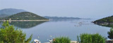
Depths exceeding 20 meters in most cases. There are several anchorages.
The SE part and W peninsula ...
3 May 11
Jojo
| Latitude | Longitude | |
| DMS | --- | --- |
| DM | --- | --- |
| DD | --- | --- |

 au camping
 marché en été
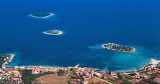
 Drace is located in the corner of a large W baieoccupée by several islands, rocks and shoals.
 Drace est situé dans l'angle W d'une grande baieoccupée par plusieurs îles, rochers et hauts-fonds.
En venant du canal Malog Stona ou de Zaliv Klek Neum, on peut se faufiler entre les îles avec prudence.
A O. Pucenjak, à 1 M à l'WNW de Rt Blaca, des fonds de 0,9 m et moins partent sur plus de 0,2 M depuis sa côte E. Sur la côte N d'O. Galicak se trouve un rocher.
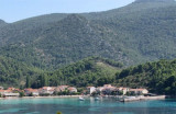
Le port de Drace est grand mais peu profond, on peut s'y amarrer sur le côté intérieur du brise-lames qui porte un feu, par 4 m ou mouiller dans le port par 4 m.
Le port est bien abrité.


Ebook | Dubrovačko-neretvanska županija (Dubrovnik–Neretva
|
Ebook | Dalmacija (Dalmatie)
|