The narrow sea from Zaliv Klek Neum is 4 NM long and lies at the NE channel Malog Stone. It is surrounded by mountains and is inserted between Rt Rep Kleka and Rt Meded. Depths exceeding 20 meters in most cases. There are several anchorages. The SE part and W peninsula ...
It is the largest and most populated island of the group Elafiten. It rises to 234 m at its N and a prominent hill rises 224 m NW of the SE end. Ruda is a small island that is 0.5 M SE of the NE extremity of the island and Misnjaka, 13 m high, lies close off the NW extremity. ...
Stonski Kanal, a deep inlet, indents the SE end of Poluotok Peljesac at the NW end of Kolocepski Kanal. Its shore rises rapidly on each side and provides protection from NE and SW winds. The village of Brocej is situated on the S shore 3.8 miles within the entrance. It is fronted ...
Drace is located in the corner of a large W baieoccupée by several islands, rocks and shoals. Approaching from the N or NE, passing between O. Goljak and O. Galicak without being too close because of shoals and a rock n O. Galicak. A tag concrete without fire indicates Plicina ...
Luka Zuljana is toward the middle of the SW coast of the peninsula of Peljesac, the E bay Zaton Zuljana. The village hosts many summer vacationers and the port is visited by charter boats based in the region. Roman tombs were found nearby. It is moored at the dock or anchored ...
This cove, closed off by the island Dubovac, offers good protection from NW to NE through S. As approaching, careful to keep at least 0.2 NM from the shore to avoid shoals and rock. Part W of the bay is occupied by the oyster. We anchored between 8 and 10 m.


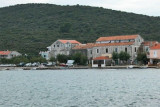
 Sreser is a hamlet in the central part of the Peljesac Peninsula on Malo More, 4 km north of Drace.
 Sreser est un hameau situé au centre de la Péninsule de Peljesac, sur Malo More, à km au N de Drace.