Luka Hiljaca (Kornati)

Luka Hiljaca (Kornati)

To precisely geolocate this site. Update if necessary.

Localisation

Characteristics

Mooring Bonne tenue
Sand

Description

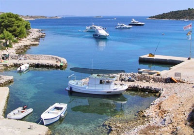
Luka Hiljaca is located on the NE coast of O. Zut, SE from Luka Zut.
The small island of Gustac protects it from the NE.
As you approach the bay by SE, attention to the isolated Shoal under 3.3 m of water to about 0.3 NM SE of O Gustac, between the island and the rock et the SE of O. Gustac. It is not advisable to navigate by night.
We anchored near the shore in 5 to 11 m.
By Bora, anchor leeward O. Gustac taking a line ashore.
Exposed to SE winds.
2011/07/16
Update
Jojo
Luka Hiljaca est situé sur la côte NE d'O. Zut, au SE de Luka Zut.
La petite île de Gustac la protège du NE.

En approchant la baie par le SE attention au haut-fond isolé sous 3,3 m d'eau à environ 0,3 NM au SE d'O Gustac, entre l'îlot et la roche au SE d'O. Gustac. Il n'est pas conseillé de naviguer de nuit.

On mouille près du rivage par 5 à 11 m.

Par Bora, mouiller sous le vent d'O. Gustac en portant une amarre à terre.

Exposé aux vents de SE.
2011/07/16
Update
Jojo
Luka Hiljaca (Kornati)
2011-07-16
Update
Jojo
Ebook

Srednji Kanal

  • 54 sites
  • 84 photos
  • publication date: 5 Aug 2024
  • .pdf file size: 26 Mb
Share your comments or photos on "Luka Hiljaca (Kornati)"

Sites around Luka Hiljaca (Kornati)

Flying distances - Direct line

Vrgadski Kanal

8.8nm
95°
Vrgadski Kanal, 7 miles long, leads between Otok Murter and Otok Vrgada and is the principal channel used in the S approach to Pasmanski Kanal and Zadar.
Vessels with a maximum draft of 6.4m may pass through Pasmanski Kanal. Vessels with drafts over 6.4m must either proceed through ...
16 Jul 11
Jojo

Otok Zirje (Sibenik)

19nm
130°
Otok Zirje is the farthest and the largest island in the Sibenik archipelago.
It is long of 6,5 NM (NW/SE) and 1,4 NM wide.
The main village, Zirje, is located in the middle of the island. A small port, luka Muna, on the coast N of Zirje, home to the ferry that connects the ...
16 Aug 11
Croatia

Kanal Nove Povljane Vir

29nm
340°
Kanal Nove Povljane, entered between Otok Vir and the SE end of Otok Pag, leads 5 miles SE into Ninski Zaliv.
Shoals at the inner end of this channel restrict the fairway to a width of about 250m, with a controlling depth of 8m. Vessels with a draft of over 6m are advised not to ...
23 Jul 11
Jojo

Novigradsko More

21nm
25°
Novigradsko More, a landlocked bay, lies at the S end of Novsko Zdrilo and provides good anchorage.
Rijeka Zrmanja flows into the bay at the E side. This river is navigable by small craft as far as the village of Obrovca, 6 miles above the mouth.
Luka Novigrad, a narrow inlet, ...
23 Jul 11
Jojo

Otok Piskera Kornati

6.1nm
174°
Piškera (known as Jadra) is a small uninhabited island and one of the Kornati island. Its area is 2,66 km². Its coastline is 10,64 km long. It is just off the SW coast of O. Kornat, about 3 NM of Vrulje.There are two islands and some reefs on the S coast.
O. Panitula Vela, the ...
18 Jul 11
Jojo