Prolaz Proversa Mala is the channel between Dugi Otok N and O. Katina S. Its depth is 4.20 m and it is well marked (red and green lateral buoys with lights). Fires also mark the approaches from offshore and the coast E of Dugi O.
2011/07/20
Update
Jojo
Prolaz Proversa Mala est le chenal entre Dugi Otok au N et O. Katina au S. Sa profondeur est de 4,20 m et il est bien balisé (bouées latérales rouges et vertes avec feux). Des feux marquent également les approches depuis le large et par la côte E de Dugi O.
2011/07/20
Update
Jojo
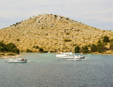
Prolaz Proversa Mala Kornati
Apperçu des Kornati avant le passage du chenal Prolaz Proversa Mala
Kanal Nove Povljane, entered between Otok Vir and the SE end of Otok Pag, leads 5 miles SE into Ninski Zaliv. Shoals at the inner end of this channel restrict the fairway to a width of about 250m, with a controlling depth of 8m. Vessels with a draft of over 6m are advised not to ...
Vrgadski Kanal, 7 miles long, leads between Otok Murter and Otok Vrgada and is the principal channel used in the S approach to Pasmanski Kanal and Zadar. Vessels with a maximum draft of 6.4m may pass through Pasmanski Kanal. Vessels with drafts over 6.4m must either proceed through ...
Otok Zirje
is the farthest and the largest island in the Sibenik archipelago. It is long of 6,5 NM (NW/SE) and 1,4 NM wide. The main village, Zirje, is located in the middle of the island. A small port, luka Muna, on the coast N of Zirje, home to the ferry that connects the ...
Ninsko-Ljubacki Kanal, a tortuous channel, connects the SE end of Kanal Nove Povljane with Ljubacka Vrata. This channel leads through the deep inlets which indent the SE coast of Otok Pag, on the NW side, and the mainland, on the SE side. It is entered between Rt Prutna,which is ...
Novigradsko More, a landlocked bay, lies at the S end of Novsko Zdrilo and provides good anchorage. Rijeka Zrmanja flows into the bay at the E side. This river is navigable by small craft as far as the village of Obrovca, 6 miles above the mouth. Luka Novigrad, a narrow inlet, ...


 quai
quai


 Prolaz Proversa Mala is the channel between Dugi Otok N and O. Katina S.
 Prolaz Proversa Mala est le chenal entre Dugi Otok au N et O. Katina au S.

 Entrance of the channel coming from the west