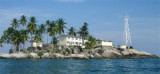
Pulau Selayar is about 6 miles long, E and W, and 2,5 miles wide. It lies between Pulau Singkep and Pulau Lingga, dividing the passage into two channels, named Selat Penuba and Selat Lima. A reef extends about 1 mile SE of Penuba, a village at the SE end of Pulau Selayar. A hill rises to a height of 300m on the W side of the island.
Kepulauan Singkeplaut (Singkep Laoet Islands), lying on a drying reef E of Tanjung Buku and fronting Teluk Baruk, consists of Pulau Keling, Pulau Tengah, Pulau Lalang, and Pulau Singkeplaut, as well as a few abovewater rocks. A conspicuous tree is reported to stand on Pulau Singkeplaut.
Tanjung Jabung (Djaboong), the SW limit of the Inner Route (N Singapore Strait from Selat Bangka via Selat Berhala and Selat Durian), is conspicious and partly overgrown with trees. Like most other parts of the Eastern coast of Sumatera, it is low land and is fronted by a mud bank ...
Pulau Berhala is a rocky island largely covered with high trees. Two bare peaks, each 91m high, rise on the W side of the island; the island is inhabited. It lies in the middle of Selat Berhala, nearly between Tanjung Jabung and Tanjung Buku, the SW end of Pulau Singkep. Except on ...
Pulau Serak, a low and wooded islet, lies about 7 miles WNW of Tanjung Buku, it is located on a shoal, which, under the depth of 9.1m, extends 2 miles SE, 1 mile N, and about 0.7 mile off either side. Oekol (Pulau Ukol), located about 0.5 mile W of the S end of Pulau Serak, lies on ...
Pulau Saya, located about 30 miles NW of Pulau-pulau Tuju, is steep-to, of granite formation, covered with wood, and has a double-peaked 210m high summit; the N peak is about 18.3m less in elevation than the S one, and both peaks are in range on a 180° and opposite bearing. A ...
The Merodong group of islands lie to the W of Pulau Mesanak, between it and the Temiang group. The former group comprises six islands, separated by channels unsuitable for navigation and there is no reason in venturing among them or between them and Pulau Mesanak. Merodong, the ...


 Pulau Selayar is about 6 miles long, E and W, and 2,5 miles wide. It lies between Pulau Singkep and Pulau Lingga, dividing the passage into two channels, named Selat Penuba and Selat Lima.