Punta Pisagua closes at S the Pisagua bay at about 2,8 NM SSW of Punta Pisagua. It is a ridge which extends about 2 NM W from the general trend of coast. There are a number of hummocks on the ridge. A conspicuous antenna stands on the ridge about 0.5 mile E of the point. A light is shown from a tower, 4m high, standing on Punta Pichalo.
2012/12/13
Update
Joëlle
Punta Pichalo est située au S de la baie de Pisagua à environ 2,8 MN SSw de Punta Pisagua. Il s'agit d'une crête qui s'étend sur environ 2 MN vers l'W. Il y a un certain nombre de buttes sur la crête. Une antenne remarquable s'élève sur la crête à environ 0,5 MN à l'E de la pointe. Un phare, tour de 4 m de haut, s'élève sur la pointe.
Pisaqua bay is located between Punta Pichalo and NE Punta Pisaga, at about 2,8 NM. The shore bank, with several islets on it, follows close along the shores of the bay. Roca Cooke, Roca Carbonera, Banco Nuevo, and Roca Osorio are dangers lying close off the shore bank and ...
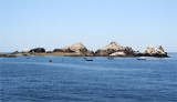
Islotes Mejillones are nearly 0.5 mile SW of the Isla Peninsula. They consist of three large and several smaller rocks of whitish color.The passage between them and the Isla Peninsula has depths of 10.1 to 14.6m, but there is a rock awash in the middle of the passage, and it should not be attempted.
Caleta Chica about 1.5 NM SE of Punta Gorda is a small cove, welle sheltered. It is difficult to identify from the S, however, a hill, 19.8 to 30m high, S of the cove, and Punta Gorda make good landmarks. The land at the head of the cove can be identified by its reddish color. The ...
Isla Peninsula lies on the S entrance point of Mejillones del Norte cove and is joined to the mainland at its NE end. Close off the N side are a number of submerged rocks and an islet.
Caleta Mejillones del Norte can be recognized easily from the N by a road which passes over the hills backing it and by Quebrada de la Aurora, a ravine a little to the S. Peninsula island and Mejillones islets are located off the coast, S cove.It is possible to anchor off the entrance ...


")
")
 Punta Pisagua closes at S the Pisagua bay at about 2,8 NM SSW of Punta Pisagua. It is a ridge which extends about 2 NM W from the general trend of coast.
 Punta Pichalo est située au S de la baie de Pisagua à environ 2,8 MN SSw de Punta Pisagua. Il s'agit d'une crête qui s'étend sur environ 2 MN vers l'W.