Uvala Sumartin, a small bay, is open to the W. It indents the W end of the Lapad Peninsula and lies between Rt Petka and Rt Gnjiliste, 0.6 mile N. Small vessels can find temporary shelter here, but anchorage is dangerous in winter.
2011/04/15
Update
Jojo
Uvala Sumartin, une petite baie, est ouverte à l'W. Elle s'étend à la fin W de la péninsule de Lapad et se situe entre Rt Petka et Rt Gnjiliste, à 0,6 mile au N. Les petits navires peuvent trouver un abri temporaire, mais le mouillage est dangereux en hiver.
It is the largest and most populated island of the group Elafiten. It rises to 234 m at its N and a prominent hill rises 224 m NW of the SE end. Ruda is a small island that is 0.5 M SE of the NE extremity of the island and Misnjaka, 13 m high, lies close off the NW extremity. ...
Zupski Zaliv is entered between Rt Sustjepan and Rt Pelegrin, 2.5 miles NW. The E and SE shores of this bay are backed by mountains, but a valley through which a river flows lies within the N shore. Malastica, 628m high, stands 1 mile N of the bay. This hill has a somewhat sharp ...
The island of Lopud belongs Elaphites. It is only 4.6 km2. It has a pleasant village and some old buildings. You'll find a sandy beach. There are two good anchorages: uvala Lopud (NW of the island), where is the village and uvala Sunj (SE of the island).
Kolocep island is located two NM from Dubrovnik. This small island is part of the archipelago of islands Elafiten. Locals also call it Kalamota. Its area is 2.35 km2. On the island there are two villages in the two largest bays of the island: Gornje Celo and Donje Celo that ...
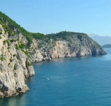
Rt Petka is the W extremity of the Lapad Peninsula, is bold, steep-to, and covered with brushwood. Mount Petka, 192m high, rises above the point. This hill has two peaks and reddish brown cliffs on its seaward side.
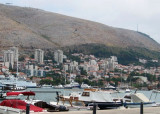
Gruz is the commercial port of Dubrovnik and has heavy traffic of freighters, ferries and cruise ships. This is the port of entry and a portion of the dock, beyond the location of Ferries, is reserved for the craft. This is the "Marina", pay, noisy and skirted by the very busy road, ...


 Uvala Sumartin, a small bay, is open to the W. It indents the W end of the Lapad Peninsula and lies between Rt Petka and Rt Gnjiliste, 0.6 mile N.
 Uvala Sumartin, une petite baie, est ouverte à l'W. Elle s'étend à la fin W de la péninsule de Lapad et se situe entre Rt Petka et Rt Gnjiliste, à 0,6 mile au N.