Rt Petka is the W extremity of the Lapad Peninsula, is bold, steep-to, and covered with brushwood. Mount Petka, 192m high, rises above the point. This hill has two peaks and reddish brown cliffs on its seaward side.
2011/04/15
Update
Jojo
Rt Petka est l'extrémité Ouest de la péninsule de Lapad, est accore, et couvert de broussailles. Mount Petka, 192m de haut, s'élève au-dessus du point. Cette colline a deux pics et falaises rougeâtres brunes du côté de la mer.
It is the largest and most populated island of the group Elafiten. It rises to 234 m at its N and a prominent hill rises 224 m NW of the SE end. Ruda is a small island that is 0.5 M SE of the NE extremity of the island and Misnjaka, 13 m high, lies close off the NW extremity. ...
Zupski Zaliv is entered between Rt Sustjepan and Rt Pelegrin, 2.5 miles NW. The E and SE shores of this bay are backed by mountains, but a valley through which a river flows lies within the N shore. Malastica, 628m high, stands 1 mile N of the bay. This hill has a somewhat sharp ...
The island of Lopud belongs Elaphites. It is only 4.6 km2. It has a pleasant village and some old buildings. You'll find a sandy beach. There are two good anchorages: uvala Lopud (NW of the island), where is the village and uvala Sunj (SE of the island).
Kolocep island is located two NM from Dubrovnik. This small island is part of the archipelago of islands Elafiten. Locals also call it Kalamota. Its area is 2.35 km2. On the island there are two villages in the two largest bays of the island: Gornje Celo and Donje Celo that ...
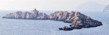
Hridi Grebeni consists of a chain of barren, jagged, and reddish above-water rocks that lie on a reef between 0.2 and 0.6 mile W of Rt Petka. A passage leads between these rocks and the point, but it is only used by small vessels with local knowledge. A light is shown from a ...
Uvala Sumartin, a small bay, is open to the W. It indents the W end of the Lapad Peninsula and lies between Rt Petka and Rt Gnjiliste, 0.6 mile N. Small vessels can find temporary shelter here, but anchorage is dangerous in winter.


 Rt Petka is the W extremity of the Lapad Peninsula, is bold, steep-to, and covered with brushwood.
 Rt Petka est l'extrémité Ouest de la péninsule de Lapad, est accore, et couvert de broussailles.