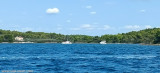
Well protected bay with 2 anchorages, to the South and North of the passage which is widely frequented. Be careful, depths are less than 3m in places. Speed limit 8 knots. Maximum available height under the bridge is 16.50m.
2024/07/25
Update
Baie bien protégé avec 2 mouillages , au Sud et au Nord du passage qui est largement fréquenté. Attention profondeurs à moins de 3m par endroit. Tirant d'air sous le pont à l'ouest de 16.50m.
2024/07/25
Update
azerty
Mouillage au NE
2024-07-25
Update
Mouillage au Sud, côté île Pasman
2024
2024-07-25
Update
Bay entrance from the west. Attention Tirant d'air maximum 16.50m
Kanal Nove Povljane, entered between Otok Vir and the SE end of Otok Pag, leads 5 miles SE into Ninski Zaliv. Shoals at the inner end of this channel restrict the fairway to a width of about 250m, with a controlling depth of 8m. Vessels with a draft of over 6m are advised not to ...
Novigradsko More, a landlocked bay, lies at the S end of Novsko Zdrilo and provides good anchorage. Rijeka Zrmanja flows into the bay at the E side. This river is navigable by small craft as far as the village of Obrovca, 6 miles above the mouth. Luka Novigrad, a narrow inlet, ...
Ninsko-Ljubacki Kanal, a tortuous channel, connects the SE end of Kanal Nove Povljane with Ljubacka Vrata. This channel leads through the deep inlets which indent the SE coast of Otok Pag, on the NW side, and the mainland, on the SE side. It is entered between Rt Prutna,which is ...
Vrgadski Kanal, 7 miles long, leads between Otok Murter and Otok Vrgada and is the principal channel used in the S approach to Pasmanski Kanal and Zadar. Vessels with a maximum draft of 6.4m may pass through Pasmanski Kanal. Vessels with drafts over 6.4m must either proceed through ...
Otok Zirje
is the farthest and the largest island in the Sibenik archipelago. It is long of 6,5 NM (NW/SE) and 1,4 NM wide. The main village, Zirje, is located in the middle of the island. A small port, luka Muna, on the coast N of Zirje, home to the ferry that connects the ...


 Well protected bay with 2 anchorages, to the South and North of the passage which is widely frequented. Be careful, depths are less than 3m in places. Speed limit 8 knots. Maximum available height under the bridge is 16.50m.
 Baie bien protégé avec 2 mouillages , au Sud et au Nord du passage qui est largement fréquenté. Attention profondeurs à moins de 3m par endroit. Tirant d'air sous le pont à l'ouest de 16.50m.
 Mouillage au NE
 Mouillage au Sud, côté île Pasman
  Bay entrance from the west. Attention Tirant d'air maximum 16.50m
 West of the bay