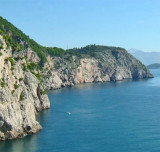
Hridi Grebeni Petka

Hridi Grebeni Petka

To precisely geolocate this site. Update if necessary.

Localisation

Characteristics

Island / Atoll
Lighthouse

Description

Hridi Grebeni consists of a chain of barren, jagged, and reddish above-water rocks that lie on a reef between 0.2 and 0.6 mile W of Rt Petka.
A passage leads between these rocks and the point, but it is only used by small vessels with local knowledge.
A light is shown from a prominent structure, 13m high, standing on the W rock of this chain. In 1872, this lighthouse was built to guide sailors to the port of Gruz. The building of the lighthouse is located near a narrow channel between two rocks.
2011/04/15
Update
Jojo
Hridi Grebeni Petka
Hridi Grebeni Petka
2011-04-15
Update
Jojo
Hridi Grebeni se compose d'une chaîne de rochers au-dessus de l'eau, stériles, déchiquetés, et rougeâtres qui se trouvent sur ​​un récif entre 0,2 et 0,6 M à l'W de Rt Petka.
Un passage mène entre ces roches et le cap, mais il n'est utilisé que par les petits navires avec des connaissances locales.
Un feu s'élève sur une structure de premier plan, haute de 13m, sur ​​le rocher à l'W de cette chaîne. C'est en 1872 que ce phare fut construit afin d'orienter les marins vers le port de Gruz. Le batiment du phare se trouve pres d'un canal etroit entre deux roches.
2011/04/15
Update
Jojo
Ebook

Dubrovačko-neretvanska županija (Dubrovnik–Neretva

  • 140 sites
  • 228 photos
  • publication date: 6 Aug 2024
  • .pdf file size: 79 Mb
Share your comments or photos on "Hridi Grebeni Petka"

Sites around Hridi Grebeni Petka

Flying distances - Direct line

Otok Sipan

8.5nm
301°
It is the largest and most populated island of the group Elafiten. It rises to 234 m at its N and a prominent hill rises 224 m NW of the SE end.
Ruda is a small island that is 0.5 M SE of the NE extremity of the island and Misnjaka, 13 m high, lies close off the NW extremity.
...
16 Apr 11
Jojo

Otok Lopud

4.6nm
295°
The island of Lopud belongs Elaphites. It is only 4.6 km2.
It has a pleasant village and some old buildings. You'll find a sandy beach.
There are two good anchorages: uvala Lopud (NW of the island), where is the village and uvala Sunj (SE of the island).
15 Apr 11
Jojo

Zupski Zaliv

7.7nm
112°
Zupski Zaliv is entered between Rt Sustjepan and Rt Pelegrin, 2.5 miles NW. The E and SE shores of this bay are backed by mountains, but a valley through which a river flows lies within the N shore.
Malastica, 628m high, stands 1 mile N of the bay. This hill has a somewhat sharp ...
13 Apr 11
Jojo

Otok Kolocep

2.3nm
301°
Kolocep island is located two NM from Dubrovnik. This small island is part of the archipelago of islands Elafiten.
Locals also call it Kalamota. Its area is 2.35 km2.
On the island there are two villages in the two largest bays of the island: Gornje Celo and Donje Celo that ...
15 Apr 11
Jojo

Rt Petka

0.4nm
104°
Rt Petka is the W extremity of the Lapad Peninsula, is bold, steep-to, and covered with brushwood.
Mount Petka, 192m high, rises above the point. This hill has two peaks and reddish brown cliffs on its seaward side.
15 Apr 11
Jojo

Uvala Sumartin

0.8nm
79°
Uvala Sumartin, a small bay, is open to the W. It indents the W end of the Lapad Peninsula and lies between Rt Petka and Rt Gnjiliste, 0.6 mile N.
Small vessels can find temporary shelter here, but anchorage is dangerous in winter.
15 Apr 11
Jojo