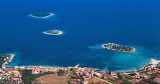
Blace is about 2 NM SE of the mouth of the river Neretva. In front of that hamlet the small Skoljic island laying a fire, is remarkable. Behind Skoljic Otok is a cove that offers good protection from all sectors. Skip to SE O. Skoljic to enter the cove, the passage is 2.5 m minimum (in the middle). We can moor up to dock, by 2 m, or anchor in the middle of the basin by 7 m.
2011/05/3
Update
Jojo
Blace se trouve à environ 2 NM au SE de l'embouchure de la rivière Neretva. Face à ce hameau la petite île de Skoljic, portant un feu, est remarquable. Derrière Otok Skoljic se trouve une anse qui offre une bonne protection de tous les secteurs.
Passer au SE d'O. Skoljic pour pénétrer dans cette anse, le passage fait 2,5 m minimum (au milieu).
On peut s'amarrer au petit quai, par 2 m, ou mouiller au milieu du bassin par 7 m.
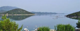
The narrow sea from Zaliv Klek Neum is 4 NM long and lies at the NE channel Malog Stone. It is surrounded by mountains and is inserted between Rt Rep Kleka and Rt Meded. Depths exceeding 20 meters in most cases. There are several anchorages. The SE part and W peninsula ...
It is the largest and most populated island of the group Elafiten. It rises to 234 m at its N and a prominent hill rises 224 m NW of the SE end. Ruda is a small island that is 0.5 M SE of the NE extremity of the island and Misnjaka, 13 m high, lies close off the NW extremity. ...
Stonski Kanal, a deep inlet, indents the SE end of Poluotok Peljesac at the NW end of Kolocepski Kanal. Its shore rises rapidly on each side and provides protection from NE and SW winds. The village of Brocej is situated on the S shore 3.8 miles within the entrance. It is fronted ...
Sreser is a hamlet in the central part of the Peljesac Peninsula on Malo More, 4 km north of Drace. The islets of Goljak, Srednjak and Gospin Skolj and the cliff Bililo are off the coast.This bay is open from N to SE through E. We can anchor by day, by 8 to 11 m.
This cove, closed off by the island Dubovac, offers good protection from NW to NE through S. As approaching, careful to keep at least 0.2 NM from the shore to avoid shoals and rock. Part W of the bay is occupied by the oyster. We anchored between 8 and 10 m.
Drace is located in the corner of a large W baieoccupée by several islands, rocks and shoals. Approaching from the N or NE, passing between O. Goljak and O. Galicak without being too close because of shoals and a rock n O. Galicak. A tag concrete without fire indicates Plicina ...


 à l'intérieur du bassin du fond, peu profond.
 Blace is about 2 NM SE of the mouth of the river Neretva. In front of that hamlet the small Skoljic island laying a fire, is remarkable.
 Blace se trouve à environ 2 NM au SE de l'embouchure de la rivière Neretva. Face à ce hameau la petite île de Skoljic, portant un feu, est remarquable.