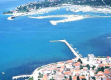
Belle vue d'avion du vieux port.
2006-09-25
Bearing:80°
2007-10-10
Update
Mobile
2011:02:08 15:58:48
2011-02-08
Update
Le Vieux Port est l'un des plus anciens de France. En 600 av. J.-C. les Phocéens débarquèrent dans la calanque du Lacydon, aujourd'hui le Vieux-Port.La Capitainerie de la Direction du Nautisme et des Plages de la Ville de Marseille offre, toute l'année des possibilités d'escale de courte durée. Pour les yachts dont la taille est inférieure à 12 mètres, escale possible sans réservation. Le Vieux Port accueille des yachts jusqu'à 90 mètres . Tirant d'eau maxi 5.5 m
Kanal Nove Povljane, entered between Otok Vir and the SE end of Otok Pag, leads 5 miles SE into Ninski Zaliv. Shoals at the inner end of this channel restrict the fairway to a width of about 250m, with a controlling depth of 8m. Vessels with a draft of over 6m are advised not to ...
Novigradsko More, a landlocked bay, lies at the S end of Novsko Zdrilo and provides good anchorage. Rijeka Zrmanja flows into the bay at the E side. This river is navigable by small craft as far as the village of Obrovca, 6 miles above the mouth. Luka Novigrad, a narrow inlet, ...
Ninsko-Ljubacki Kanal, a tortuous channel, connects the SE end of Kanal Nove Povljane with Ljubacka Vrata. This channel leads through the deep inlets which indent the SE coast of Otok Pag, on the NW side, and the mainland, on the SE side. It is entered between Rt Prutna,which is ...
Vrgadski Kanal, 7 miles long, leads between Otok Murter and Otok Vrgada and is the principal channel used in the S approach to Pasmanski Kanal and Zadar. Vessels with a maximum draft of 6.4m may pass through Pasmanski Kanal. Vessels with drafts over 6.4m must either proceed through ...
Otok Zirje
is the farthest and the largest island in the Sibenik archipelago. It is long of 6,5 NM (NW/SE) and 1,4 NM wide. The main village, Zirje, is located in the middle of the island. A small port, luka Muna, on the coast N of Zirje, home to the ferry that connects the ...
The large Sukosan bay is located around 5,5 NM SE Zadar. It has a small port, but especially the largest marina in Dalmatia, Marina Dalmacija. The village was inhabited from the Roman period and among the remains of this era are the remains of an aqueduct. Approach: Sukosan ...


 3000 postes d'amarrage
 0 491 55 31 36
  Belle vue d'avion du vieux port.
2006-09-25
Bearing:80°
Belle vue d'avion du vieux port.
2006-09-25
Bearing:80°