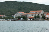
The Trstenik port is located at N Zaton Zuljana at the bottom of a hill covered with vines. The breakwater Trstenik has a fire at its end (metal painted in red). A chapel is located across from the breakwater. We moore on to the breakwater or pier or anchored in the middle is the port by 11 m. Sheltered harbor in summer but not winter.
2014/05/5
Update
Perfect for yachts and tourist ships. Trstenik offers cafes, wine and cocktail bars, three restaurants two pizzerias a supermarket and a postal office. Wine tour buses are ready to organize Trstenik and Dingac wine tours.
2014/05/5
Update
Le port de Trstenik se trouve au N de Zaton Zuljana, au pied d'une colline couverte de vignes.
Le brise-lames de Trstenik a un feu à son extrémité (structure métallique peinte en rouge). Une chapelle se trouve en face du brise-lames.
On s'amarre au brise-lames ou au quai ou on mouille au milieu du port par 11 m.
The narrow sea from Zaliv Klek Neum is 4 NM long and lies at the NE channel Malog Stone. It is surrounded by mountains and is inserted between Rt Rep Kleka and Rt Meded. Depths exceeding 20 meters in most cases. There are several anchorages. The SE part and W peninsula ...
It is the largest and most populated island of the group Elafiten. It rises to 234 m at its N and a prominent hill rises 224 m NW of the SE end. Ruda is a small island that is 0.5 M SE of the NE extremity of the island and Misnjaka, 13 m high, lies close off the NW extremity. ...
Stonski Kanal, a deep inlet, indents the SE end of Poluotok Peljesac at the NW end of Kolocepski Kanal. Its shore rises rapidly on each side and provides protection from NE and SW winds. The village of Brocej is situated on the S shore 3.8 miles within the entrance. It is fronted ...
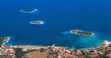
Skoji is a group of islands in Korcula Archipelago, located in Peljesac Channel in Croatia. There are all together 19 small islands that form this archipelago. Their names are : Badija, Kamenjak, Gojak, Planjak, Vrnik, Majsan, Majsanic, Gubavac, Knezic, Bisace, Sutvara, Stupe, Baretica, ...
Drace is located in the corner of a large W baieoccupée by several islands, rocks and shoals. Approaching from the N or NE, passing between O. Goljak and O. Galicak without being too close because of shoals and a rock n O. Galicak. A tag concrete without fire indicates Plicina ...
Sreser is a hamlet in the central part of the Peljesac Peninsula on Malo More, 4 km north of Drace. The islets of Goljak, Srednjak and Gospin Skolj and the cliff Bililo are off the coast.This bay is open from N to SE through E. We can anchor by day, by 8 to 11 m.


 The Trstenik port is located at N Zaton Zuljana at the bottom of a hill covered with vines.
 Le port de Trstenik se trouve au N de Zaton Zuljana, au pied d'une colline couverte de vignes.