Red beacon on east side of the entrance of thé bay
2024-07-22
Update
2024
2024-07-23
Update
AB
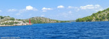
Bay sheltered from all winds except S and SE. The bay is part of the Telascica Nature Park. A residence fee is charged by the guards who will take away your trash. We anchor in 5 m of water towards the back of the bay.
2024/08/7
Update
azerty
Baie abritée de tous les vents sauf du S et SE. La baie fait partie du parc naturel de Telascica. Un droit de séjour est perçu par les gardes qui emporteront vos poubelles. On mouille par 5 m de fond vers le fond de la baie.
2008/09/7
Update
Share your comments or photos on "Uvala Cuscica (Dugi otok)."
Kanal Nove Povljane, entered between Otok Vir and the SE end of Otok Pag, leads 5 miles SE into Ninski Zaliv. Shoals at the inner end of this channel restrict the fairway to a width of about 250m, with a controlling depth of 8m. Vessels with a draft of over 6m are advised not to ...
Vrgadski Kanal, 7 miles long, leads between Otok Murter and Otok Vrgada and is the principal channel used in the S approach to Pasmanski Kanal and Zadar. Vessels with a maximum draft of 6.4m may pass through Pasmanski Kanal. Vessels with drafts over 6.4m must either proceed through ...
Otok Zirje
is the farthest and the largest island in the Sibenik archipelago. It is long of 6,5 NM (NW/SE) and 1,4 NM wide. The main village, Zirje, is located in the middle of the island. A small port, luka Muna, on the coast N of Zirje, home to the ferry that connects the ...
Ninsko-Ljubacki Kanal, a tortuous channel, connects the SE end of Kanal Nove Povljane with Ljubacka Vrata. This channel leads through the deep inlets which indent the SE coast of Otok Pag, on the NW side, and the mainland, on the SE side. It is entered between Rt Prutna,which is ...
Novigradsko More, a landlocked bay, lies at the S end of Novsko Zdrilo and provides good anchorage. Rijeka Zrmanja flows into the bay at the E side. This river is navigable by small craft as far as the village of Obrovca, 6 miles above the mouth. Luka Novigrad, a narrow inlet, ...
Prolaz Proversa Mala is the channel between Dugi Otok N and O. Katina S. Its depth is 4.20 m and it is well marked (red and green lateral buoys with lights). Fires also mark the approaches from offshore and the coast E of Dugi O.


 Bonne tenue.
.")
.") Red beacon on east side of the entrance of thé bay
Red beacon on east side of the entrance of thé bay.")
 Bay sheltered from all winds except S and SE. The bay is part of the Telascica Nature Park. A residence fee is charged by the guards who will take away your trash.
 Baie abritée de tous les vents sauf du S et SE. La baie fait partie du parc naturel de Telascica. Un droit de séjour est perçu par les gardes qui emporteront vos poubelles.